November 17: 40 Thai provinces brace for storms, strong winds

The Thai Meteorological Department (TMD) issued a warning today, November 17, as severe storms and strong winds are forecast to sweep across 40 provinces, with the upper region facing erratic conditions and southern seas seeing waves of over two metres.
The TMD announced that a strong high-pressure system from central China is expected to move across southern China and northern Vietnam today, reaching Thailand’s upper regions tomorrow, November 18. This shift will bring fluctuating weather, with thunderstorms and gusty winds in the north and northeast.
Meanwhile, the southern region will experience scattered thunderstorms as the northeast monsoon continues to affect the Gulf of Thailand, southern Thailand, and the Andaman Sea. Waves in the Gulf are expected to reach two metres, surging even higher in thunderstorm zones.
Regional weather breakdown
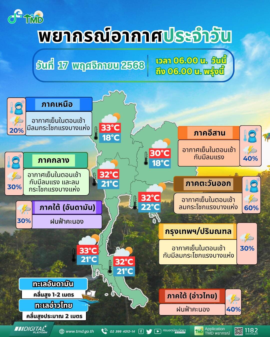
North Thailand:
Cool mornings with thunderstorms in 20% of the area and occasional strong winds are expected, particularly in Nan, Phichit, Phitsanulok, and Phetchabun. Daytime temperatures will hover between 29 to 33°C, with morning lows from 18 to 23°C. Mountainous areas could drop to a chilly 7 to 15°C. Winds: northeast, 10 to 15km/h.
Northeast Thailand:
Rain is forecast in 40% of the region, with strong winds and cool mornings. Affected provinces include Sakon Nakhon, Nakhon Phanom, Khon Kaen, Kalasin, Mukdahan, Maha Sarakham, Roi Et, Yasothon, Amnat Charoen, Buri Ram, Surin, Si Sa Ket, and Ubon Ratchathani. Temperatures: 18 to 22°C (low), 26 to 30°C (high); mountain lows as cold as 12 to 16°C. Winds: northeast, 10 to 30km/h.
Central Thailand:
Expect a cool start to the day and thunderstorms in 30% of the area, especially in Nakhon Sawan, Chai Nat, Sing Buri, Ang Thong, Lop Buri, Saraburi, and Ayutthaya. Temperatures: 21 to 23°C (low), 30 to 32°C (high). Winds: northeast, 10 to 25km/h.


East Thailand:
Thunderstorms will hit 60% of the region, notably in Prachin Buri, Sa Kaeo, Chachoengsao, Rayong, Chanthaburi, and Trat. Temperatures: 22 to 23°C (low), 30 to 32°C (high). Winds: northeast, 20 to 35km/h. Sea conditions: one-metre waves, increasing to two metres offshore.
South (East Coast):
Thunderstorms are expected in 40% of the area, including Prachuap Khiri Khan, Chumphon, Surat Thani, Songkhla, Pattani, Yala, and Narathiwat. Temperatures: 21 to 25°C (low), 30 to 32°C (high). Winds: northeast, 20 to 35km/h. Waves: around two metres, higher during storms.
South (West Coast):
Around 30% of the region, including Krabi, Trang, and Satun, will face thunderstorms. Temperatures: 21 to 24°C (low), 31 to 33°C (high). From Krabi northwards, expect one-metre waves and 1 to 2 metres offshore. From Trang southwards, waves will be about one metre or higher in storms. Winds: northeast, 15 to 35km/h north of Krabi, 15 to 30km/h south of Trang.
Bangkok and surrounding areas:
Thunderstorms in 30% of the city, accompanied by strong winds. Temperatures: 22 to 23°C (low), 31 to 32°C (high). Winds: northeast, 10 to 20km/h.
Latest Thailand News


Follow The Thaiger on Google News: