Thailand braces for showers, chilly air and rough seas ahead
Strong winds and high waves expected across coastal regions

Thailand will experience cooler mornings and scattered rain as changing weather patterns bring showers and wind to several regions across the country.
A high-pressure system over upper Thailand and a low-pressure cell near southern Vietnam are bringing rain, cool mornings, and rough seas nationwide.
The weather forecast from 6pm yesterday, October 28, to 6pm today, October 29, is as follows:
In the northern region, cool mornings are expected with isolated rainfall in provinces such as Tak, Kamphaeng Phet, Phitsanulok, Phichit, and Phetchabun. Temperatures will range from 18 to 24°C, dropping to 8 to 17°C on mountain tops. Northeasterly winds will blow at 10 to 15 km/h.
Northeast Thailand will also see a cool start to the day, with scattered showers likely in Sakon Nakhon, Nakhon Phanom, Kalasin, Mukdahan, Maha Sarakham, Roi Et, Yasothon, Amnat Charoen, Nakhon Ratchasima, Buriram, Surin, Sisaket, and Ubon Ratchathani. Temperatures will dip to 20 to 24°C, or 14 yo 18°C in the mountains, rising to 28 to 32°C by day. Winds will be from the northeast at 10 to 25 km/h.
Central Thailand will remain mostly cloudy with isolated rain across Nakhon Sawan, Uthai Thani, Kanchanaburi, Ratchaburi, Samut Sakhon, and Samut Songkhram. Temperatures will range between 22 and 25°C in the morning and 30 to 33°C during the day, with northeasterly winds of 10 to 20 km/h.
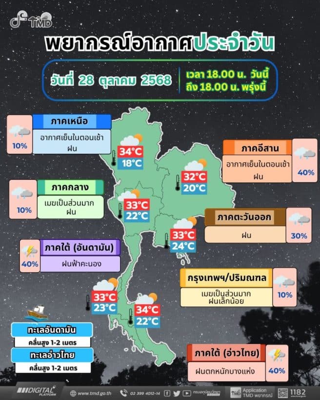
In the east, isolated showers are expected in Nakhon Nayok, Prachin Buri, Sa Kaeo, Rayong, Chanthaburi, and Trat. Morning temperatures will sit at 24 to 26°C, with daytime highs of 30 to 33°C. Northeasterly winds will reach 15 to 35 km/h, and seas may rise to 1 metre near the coast, 1 to 2 metres offshore, and over 2 metres in thundershowers.


The southern east coast will experience scattered thundershowers and isolated heavy rain in Chumphon, Surat Thani, and Nakhon Si Thammarat. Temperatures will range from 22 to 26°C to 30 to 34°C. Wind speeds will vary between 15 and 35 km/h in the north and 15 and 30 km/h further south. Waves may reach 1 to 2 metres and exceed 2 metres during storms.
Along the west coast, expect scattered thundershowers, particularly in Ranong, Phang Nga, Phuket, and Krabi. Temperatures will range from 23 to 25°C up to 31 to 33°C. Variable winds will blow at 15 to 35 km/h north of Phuket and northwesterly at 15 to 30 km/h further south, with waves reaching 1 to 2 metres and over 2 metres in stormy conditions, according to the Thai Meteorological Department (TMD).

Bangkok and surrounding areas will remain cloudy with occasional isolated showers. Morning temperatures will be around 25 to 27°C, rising to 30 to 32°C. Winds will be from the northeast at 10 to 20 km/h.
Latest Thailand News


Follow The Thaiger on Google News: