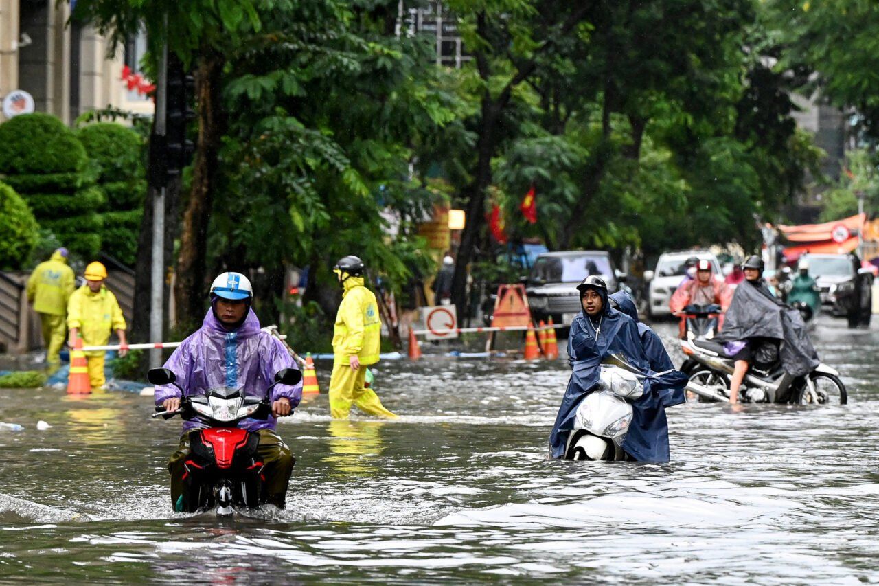
Thailand braces for heavy rain as monsoon pushes south
Public urged to stay alert as stormy conditions sweep across regions

The Thai Meteorological Department (TMD) has warned of widespread rain and storms affecting several regions, urging the public to remain cautious due to possible hazards.
The monsoon trough has shifted down to lie across the lower central region and the East, while the southwest monsoon continues to affect the Andaman Sea, the South, and the Gulf of Thailand. This weather pattern will bring increased rainfall, particularly in the central region, including Bangkok, as well as in the East and the South. Isolated heavy showers are expected, and residents are urged to remain alert to the risk of flash flooding.
The weather forecast for 6pm today, October 9, to 6pm tomorrow, October 10, is as follows:
In the North, scattered thundershowers are expected, particularly in provinces such as Mae Hong Son, Chiang Mai, Tak, Kamphaeng Phet, Phitsanulok, and Phetchabun. Temperatures will range from 22 to 26°C in the morning, rising to a maximum of 32 to 35°C during the day. Winds will be easterly at 5 to 15 km/h.
Northeast Thailand can expect isolated thundershowers, mainly affecting Chaiyaphum, Nakhon Ratchasima, Buriram, and Surin. Minimum temperatures will fall between 22 and 25°C, with daytime highs of 32 to 34°C. Easterly winds will range from 10 to 20 km/h.
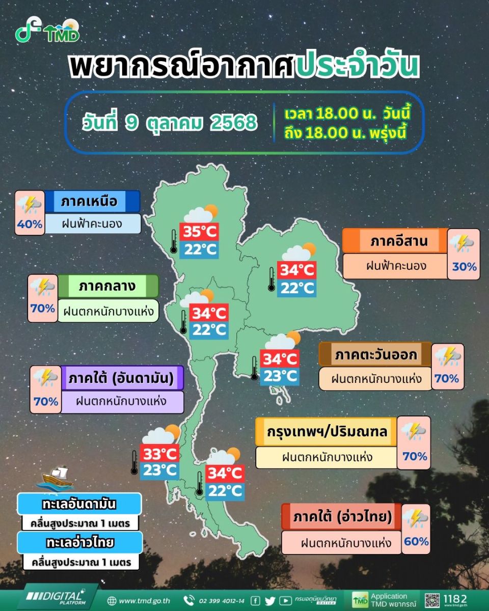
In the central region, fairly widespread thundershowers are predicted, with isolated heavy rainfall particularly in Kanchanaburi, Phra Nakhon Si Ayutthaya, Ratchaburi, Nakhon Pathom, Samut Songkhram, and Samut Sakhon. Temperatures will range from 22 to 25°C in the morning, peaking at 32 to 34°C later in the day. Winds will be variable at 10 to 20 km/h.
The eastern region will experience similar conditions, with fairly widespread thundershowers and isolated heavy downpours expected in Nakhon Nayok, Prachinburi, Chachoengsao, Chon Buri, Rayong, Chanthaburi, and Trat. Morning lows will be between 23 and 25°C, while daytime temperatures will reach 31 to 34°C. Variable winds of 15 to 30 km/h are expected, with wave heights of around 1 metre, increasing to over 2 metres during thundershowers.


On the east coast in the South, scattered thundershowers and isolated heavy rain are likely in Chumphon, Surat Thani, Nakhon Si Thammarat, Songkhla, Pattani, and Narathiwat. Morning temperatures will sit between 22 and 24°C, climbing to 32 to 34°C during the day. North of Prachuap Khiri Khan, winds will be variable at 15 to 30 km/h; from Chumphon downward, expect southwesterly winds at the same speed. Seas will be about 1 metre high, rising to over 2 metres during storms.
The west coast will see fairly widespread thundershowers with isolated heavy rain in Phang Nga, Phuket, Krabi, Trang, and Satun. Temperatures will range from 23 to 25°C at night, with daytime highs of 30 to 33°C. Southwesterly winds will blow at 15 to 30 km/h, and wave heights will reach about 1 metre, exceeding 2 metres in thundershowers.

The Bangkok Metropolitan Region can expect fairly widespread thundershowers and isolated heavy rain. Temperatures will range from 24 to 26°C in the early morning, climbing to 32 to 34°C. Variable winds will blow at 10 to 20 km/h, according to the TMD.
The TMD advises ships in the Gulf of Thailand and the Andaman Sea to proceed with caution and avoid areas with thundershowers due to potentially hazardous wave conditions.
Latest Thailand News


Follow The Thaiger on Google News: