May 21 forecast brings heavy rain, rough seas as monsoon grips Thailand
Thailand will continue to face heavy rain in several regions today, May 21, with the Thai Meteorological Department (TMD) warning of flash floods, forest runoff and rough seas in parts of the country, according to today’s weather forecast.
The department said a moderately strong southwest monsoon covering the upper Andaman Sea and Thailand, combined with a low-pressure cell over the lower North and upper Northeast, would bring continued rainfall and isolated heavy to very heavy rain.
People in affected areas were urged to remain cautious of heavy rainfall and accumulated rain, particularly near foothills, waterways and low-lying areas that may be vulnerable to flash floods and runoff.
Waves in the upper Andaman Sea are expected to reach two to three metres, and more than three metres in areas with thunderstorms. Waves in the lower Andaman Sea and upper Gulf of Thailand are forecast at around two metres, rising above two metres during thunderstorms.
The department advised sailors to proceed with caution and avoid storm areas. Small boats in the upper Andaman Sea were advised to remain ashore.
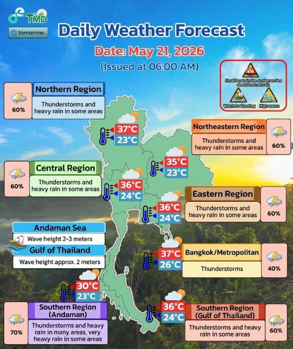
The weather forecast for the 24 hours from 6am today to 6am tomorrow predicts thunderstorms across much of the country.
In North Thailand, thunderstorms are expected in 60% of the region, with heavy rain in some areas. Temperatures are expected to range between 23°C and 37°C.


Affected northern provinces are as follows: Nan, Uttaradit, Sukhothai, Tak, Kamphaeng Phet, Phichit, Phitsanulok and Phetchabun.
In the Northeast, thunderstorms are expected in 60% of the region, with heavy rain in some areas. Temperatures are expected to range between 23°C and 35°C.
Affected northeastern provinces are as follows: Loei, Nong Khai, Bueng Kan, Nong Bua Lamphu, Udon Thani, Sakon Nakhon and Nakhon Phanom.
In Central Thailand, thunderstorms are expected in 60% of the region, with heavy rain in some areas. Temperatures are expected to range between 24°C and 36°C.
Affected central provinces are as follows: Nakhon Sawan, Uthai Thani, Chai Nat, Suphan Buri, Kanchanaburi and Ratchaburi.
In East Thailand, thunderstorms are expected in 60% of the region, with heavy rain in some areas. Temperatures are expected to range between 24°C and 36°C. Waves are forecast at around two metres and above two metres during thunderstorms.
Affected eastern provinces are as follows: Rayong, Chanthaburi and Trat.

In South Thailand’s east coast, thunderstorms are expected in 60% of the region, with heavy rain in some areas. Temperatures are expected to range between 24°C and 36°C.
Affected provinces are as follows: Phetchaburi, Prachuap Khiri Khan, Chumphon, Surat Thani, Nakhon Si Thammarat, Phatthalung and Songkhla.
From Surat Thani northward, waves are forecast at around two metres and above two metres offshore and during thunderstorms.
From Nakhon Si Thammarat southward, waves are expected at one to two metres, around two metres offshore and above two metres during thunderstorms.
In South Thailand’s west coast, thunderstorms are expected in 70% of the region, with heavy rain in many areas and very heavy rain in some places. Temperatures are expected to range between 23°C and 30°C.
Affected provinces for heavy rain are as follows: Phuket, Krabi, Trang and Satun. Ranong and Phang Nga are forecast to see very heavy rain.
From Phuket northward, waves are forecast at two to three metres and above three metres during thunderstorms.
From Krabi southward, waves are expected at around two metres and above two metres during thunderstorms.
In Bangkok and nearby provinces, thunderstorms are forecast across 40% of the area, with temperatures ranging from 26°C to 37°C.
Latest Thailand News


Follow The Thaiger on Google News: