Thailand hit by unseasonal chill and heavy rain warnings
TMD urges caution as storms threaten multiple regions

Thailand is facing a weather shake-up as cool mornings and heavy rains sweep across several regions, prompting warnings for residents and farmers nationwide.
A low-pressure system over the Cape of Annam and weakening high-pressure in upper Thailand are triggering widespread rain and storms, especially in northeastern and southern provinces. The Thai Meteorological Department (TMD) warns of flooding risks and crop damage, urging locals and farmers to prepare and protect their health amid unstable conditions.
The weather forecast from 6am today, October 30, to 6am tomorrow, October 31, is as follows:
Across the northern regions, expect a cool morning with isolated rain or thunderstorms, especially in Tak, Kamphaeng Phet, Phitsanulok, Phichit, and Phetchabun. Minimum temperatures will range from 18 to 25°C, with chilly mountain tops dipping as low as 8 to 17°C. Northeasterly winds are forecast at 10 to 15 km/h.
In northeastern Thailand, morning temperatures will hover between 21 and 24°C. Scattered thundershowers and isolated heavy rains are likely in Khon Kaen, Maha Sarakham, Roi Et, Nakhon Ratchasima, Buriram, Surin, Sisaket, and Ubon Ratchathani. Mountainous areas may see lows of 15 to 19°C. Winds will range from 10 to 25 km/h.
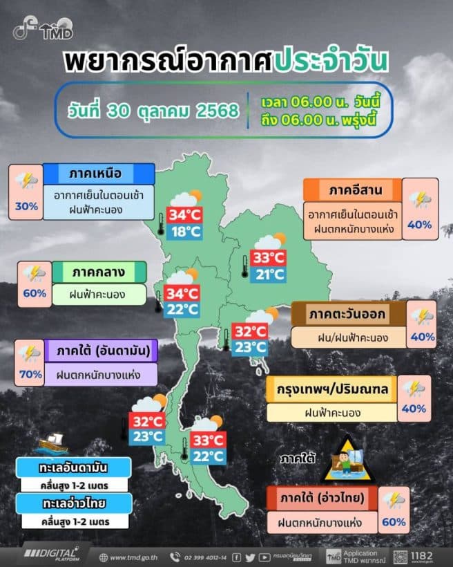
Central provinces can expect cloudy skies with isolated thunderstorms in Nakhon Sawan, Uthai Thani, Chainat, Kanchanaburi, Ratchaburi, Samut Sakhon, and Samut Songkhram. Temperatures will range from 22 to 25°C in the morning, rising to 31 to 34°C during the day, with winds of 10 to 20 km/h.


Eastern Thailand will see scattered showers and thunderstorms, especially in Nakhon Nayok, Prachinburi, Chachoengsao, Sa Kaeo, Rayong, Chanthaburi, and Trat. Minimum temperatures will sit between 24 and 26°C, with daytime highs of 28 to 32°C. Northeasterly winds will pick up to 15 to 35 km/h, creating waves of about 1 metre, rising to 2 metres offshore and over 2 metres during thunderstorms.
Along the east coast of southern Thailand, including Prachuap Khiri Khan, Chumphon, Surat Thani, and Nakhon Si Thammarat, scattered thunderstorms and isolated heavy rain are expected. Morning lows will range from 22 to 25°C, with highs between 30 and 33°C. Waves in the upper Gulf are forecast at 1 to 2 metres, surging past 2 metres in thunderstorms.

The west coast, including Ranong, Phang Nga, Phuket, Krabi, and Satun, faces fairly widespread thunderstorms and isolated heavy rainfall. Temperatures will sit between 23 and 25°C in the morning and climb to 29 to 32°C during the day. Winds from Phuket upward will blow at 15 to 35 km/h, generating waves of 1 to 2 metres and exceeding 2 metres in stormy conditions, according to TMD.
From Krabi downward, northwesterly winds of 15 to 30 km/h will produce 1 metre waves, with similar surges in storm zones.
In Bangkok, residents should expect cloudy skies with isolated rain or thunderstorms. Morning temperatures will remain warm at 25 to 27°C, peaking at 31 to 33°C later in the day, with northeasterly winds at 10 to 20 km/h.
Latest Thailand News


Follow The Thaiger on Google News: