New cold surge to sweep Thailand, drop 4°C from Jan 21

Thailand Braces for New Cold Surge: Temperatures to Drop 2-4°C Starting Jan 21
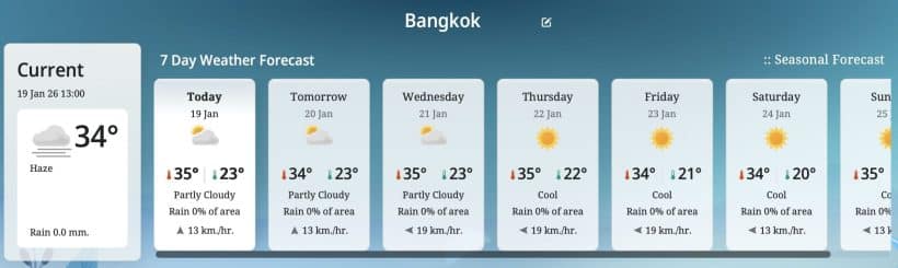
BANGKOK – The Thai Meteorological Department (TMD) announced a weather warning on January 19, 2026, advising residents to prepare for a new moderate high-pressure system from China. This cold air mass will cover upper Thailand and the South China Sea, causing temperatures to plummet by 2-4°C across most regions between January 21 and 25.
National Outlook January 20–24
Upper Thailand will experience cool to cold weather with an initial temperature drop of 1-3°C.
-
Northern Thailand: Cool to cold with morning fog; thick fog in some areas. Lows of 11-18°C. Mountain peaks will be very cold with isolated frost, reaching lows of 3-12°C.
-
Northeast: Temperatures will drop 1-3°C. Lows of 13-20°C, while mountain tops will see lows of 4-12°C.
-
Central & Eastern Regions: Cool mornings with a 1-2°C drop in temperature. Isolated light rain is expected along the eastern coasts.
-
Bangkok & Vicinity: Cool mornings with fog. Temperatures will decrease by 1-2°C, with lows ranging between 22-24°C.
-


Southern Thailand & Sea Conditions
The Southern region will see an increase in rainfall from January 21 to 24 due to the strengthening Northeast Monsoon.
-
East Coast (Gulf of Thailand): 20-30% chance of thunder showers. From Nakhon Si Thammarat southward, waves will reach 1-2 meters, exceeding 2 meters in stormy areas.
-
West Coast (Andaman Sea): Isolated thunder showers (10-20% of the area). Waves will remain around 1 meter.
Regional Temperature Summary (Jan 19–24)
Latest Thailand News


Follow The Thaiger on Google News: