Tidal wave of trouble: Phitsanulok fields flooded as waters overflow
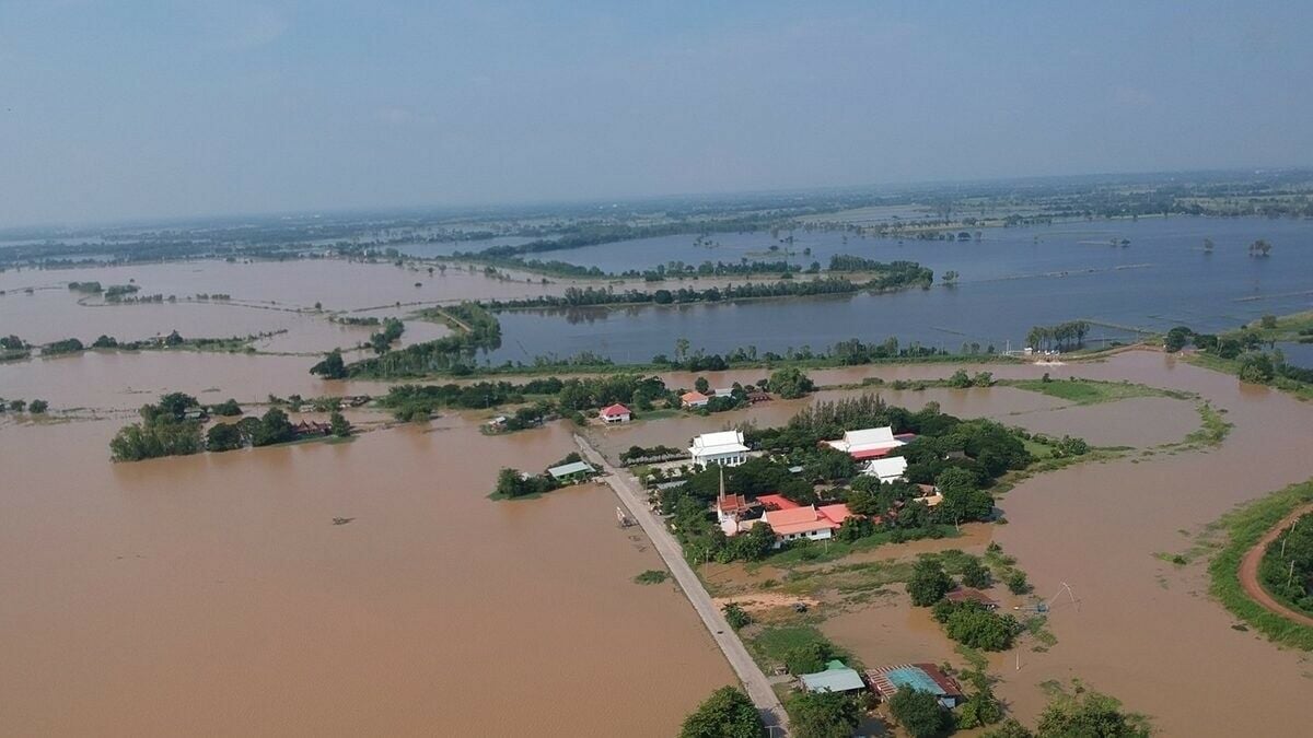
Floodwaters are inundating the Bang Rakam model fields in Phitsanulok province, receiving overflow from Sukhothai and reaching 571 million cubic metres, or 143% of capacity. The water expands, flooding nearby areas and roads, particularly in Phrom Phiram, Mueang, and Bang Rakam districts.
Since late September, 304 villages across 50 subdistricts in nine districts of Phitsanulok have been affected by floodwaters originating from the upper Yom River. This deluge has swelled the Bang Rakam model fields, a designated flood storage area, beyond its capacity.
Chamnarn Chutiang, the Phitsanulok irrigation officer, reported that the flood storage fields have already exceeded their capacity, accommodating 571 million cubic metres of water, which is 143% of their intended limit. The inundated area covers 212,588 rai, or approximately 80% of the total flood storage area.
The rapid increase in water levels has led to the flooding of several village roads within the Bang Rakam model area, especially around Ban Mae Rahan. The overflow has extended beyond the storage fields, affecting surrounding communities and inter-village roads. Residents in these areas have resorted to using boats for transportation due to the submerged roads.
The water level in the main Yom River, which flows through Bang Rakam district, continues to rise. At the Y.64 water measurement station, the river’s flow rate reached 908.1 cubic metres per second, with the water level standing at 9.59 metres, which is 3.08 metres above the riverbank and 2.18 metres above the critical level for community areas.
The water level has increased by 11 centimetres from the previous day and is expected to rise by an additional 30 centimetres over the next one or two days, although the rate of increase is slowing.
Phitsanulok province remains vigilant, particularly in low-lying areas of Bang Rakam, Mueang, and Phrom Phiram districts. Local officials have urged residents living near the main and old Yom River to remain alert and monitor vulnerable riverbank areas. They are advised to reinforce riverbanks, prepare to move belongings to higher ground and exercise caution with electrical appliances in flood-prone areas.


Meanwhile, the Sirikit Dam currently holds 8,965 million cubic metres of water, or 94% of its capacity, with a planned release of 4.99 million cubic metres today. The Kwae Noi Bamrung Daen Dam contains 753 million cubic metres, or 80% of its capacity, with a planned release of 0.43 million cubic metres yesterday, October 9, said Chamnarn.
“The flood storage fields have already exceeded their capacity, accommodating 571 million cubic metres of water, which is 143% of their intended limit.”
The situation highlights the persistent challenge of managing floodwaters in the region, particularly during the monsoon season. Officials continue to monitor the situation closely and implement measures to mitigate the impact on affected communities while keeping the public informed about safety precautions and necessary actions, reported KhaoSod.
What Other Media Are Saying
- Today Line reports heavy flooding in Tung Bang Rakham, Phitsanulok, with 571 million cubic metres of water, 143% above capacity, causing widespread inundation and affecting local communities. (read more)
- Thai Post article highlights significant flooding in Thung Bang Rakam Model, Pitsanulok, with rising water levels affecting locals and agricultural land, emphasizing preparedness and community resilience. (read more)
Frequently Asked Questions
Here are some common questions asked about this news
How much water are the Bang Rakam model fields currently holding?
571 million cubic metres, which is 143% of its capacity.
Which areas in Phitsanulok Province are most affected by the flooding?
Phrom Phiram, Mueang, and Bang Rakam districts are particularly affected.
How many villages in Phitsanulok have been impacted by the floodwaters?
304 villages across 50 subdistricts in nine districts.
What is the current water level in the main Yom River at the Y.64 measurement station?
The water level is 9.59 metres, 3.08 metres above the riverbank.
What precautions are authorities advising residents to take?
Reinforce riverbanks, move belongings to higher ground, and exercise caution with electrical appliances.
Latest Thailand News


Follow The Thaiger on Google News: