Weather forecast: Thai downpour alert drenches 48 provinces, Bangkok braces for a washout

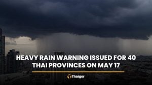
A continuous rainfall weather forecast has been issued today for 48 provinces by the Thai Meteorological Department (TMD), with the capital Bangkok included. The situation is most severe in the southern region, where 60% of the area is experiencing heavy rainfall. As a result, sudden flash floods and forest run-off are expected today.
An area of high atmospheric pressure or a cool air mass is currently covering the upper part of Thailand and the South China Sea. This is causing eastern and south-eastern winds to sweep across the lower northeastern region, central region, including Bangkok and its vicinity, and the eastern region.
As a result, the upper part of Thailand continues to experience thunderstorms, with heavy downpours in some areas in the central and eastern regions.
A monsoon trough is passing through the upper southern region, while a south-western monsoon is prevailing over the Andaman Sea, the lower southern region, and the lower Gulf of Thailand. This is causing heavy rainfall in some southern areas.
The inhabitants of the southern region are warned of the dangers from heavy rain and accumulated rainfall, which could lead to sudden flash floods and forest run-off, especially in hillside areas near waterways and low-lying areas.
Caution is advised when travelling through areas with thunderstorms. For the Andaman Sea and the Gulf of Thailand, waves are about 1 metre high. In thunderstorm areas, waves can be more than 2 metres high. Boat operators are advised to navigate with caution and avoid sailing in thunderstorm areas.
Regions Affected


In the northern region, there are thunderstorms in 40% of the area, mainly in Mae Hong Son, Chiang Mai, Tak, Sukhothai, Kamphaeng Phet, Phichit, Phitsanulok, and Phetchabun provinces. The lowest temperature ranges from 22 to 26 degrees Celsius and the highest temperature from 31 to 35 degrees Celsius, with easterly winds at a speed of 10 to 15 kilometres per hour.
In the northeastern region, there are thunderstorms in 40% of the area, mainly in Nakhon Phanom, Chaiyaphum, Khon Kaen, Maha Sarakham, Roi Et, Yasothon, Mukdahan, Amnat Charoen, Nakhon Ratchasima, Buriram, Surin, Si Sa Ket, and Ubon Ratchathani provinces. The lowest temperature ranges from 22 to 25 degrees Celsius and the highest temperature from 32 to 34 degrees Celsius, with easterly winds at a speed of 10 to 20 kilometres per hour.
In the central region, there are thunderstorms in 40% of the area, with heavy rainfall in some places in Nakhon Sawan, Uthai Thani, Kanchanaburi, Suphan Buri, Lop Buri, Saraburi, Phra Nakhon Si Ayutthaya, and Ratchaburi provinces. The lowest temperature ranges from 23 to 26 degrees Celsius and the highest temperature from 31 to 35 degrees Celsius, with south-easterly winds at a speed of 10 to 20 kilometres per hour.
In the eastern region, there are thunderstorms in 40% of the area, with heavy rainfall in some places in Nakhon Nayok, Chon Buri, Rayong, Chanthaburi, and Trat provinces.
The lowest temperature ranges from 24 to 26 degrees Celsius and the highest temperature from 32 to 34 degrees Celsius, with south-easterly winds at a speed of 15 to 30 kilometres per hour. The sea has waves about 1 metre high.
In thunderstorm areas, waves can be more than 2 metres high as predicted by the weather forecast.
Impending Thunderstorms
In the southern region (East Coast), the weather forecast predicts that there are thunderstorms in 60% of the area, with heavy rainfall in some places in Chumphon, Surat Thani, Nakhon Si Thammarat, Pattani, Yala, and Narathiwat provinces. The lowest temperature ranges from 23 to 25 degrees Celsius and the highest temperature from 32 to 34 degrees Celsius.
From Surat Thani province upwards, there are variable winds at a speed of 15 to 30 kilometres per hour. The sea has waves about 1 metre high. In thunderstorm areas, waves can be more than 2 metres high. From Nakhon Si Thammarat province downwards, there are south-westerly winds at a speed of 15 to 30 kilometres per hour. The sea has waves about 1 metre high. In thunderstorm areas, waves can be more than 2 metres high reported KhaoSod.
In the southern region (West Coast), there are thunderstorms in 60% of the area, with heavy rainfall in some places in Phang Nga, Phuket, Krabi, Trang, and Satun provinces. The lowest temperature ranges from 23 to 26 degrees Celsius and the highest temperature from 32 to 34 degrees Celsius, with westerly winds at a speed of 15 to 30 kilometres per hour. The sea has waves about 1 metre high. In thunderstorm areas, waves can be more than 2 metres high.
In Bangkok and its vicinity, there are thunderstorms in 40% of the area. The lowest temperature ranges from 25 to 27 degrees Celsius and the highest temperature from 32 to 35 degrees Celsius, with southerly winds at a speed of 10 to 20 kilometres per hour.
Follow more of The Thaiger’s latest stories on our new Facebook page HERE.
Latest Thailand News


Follow The Thaiger on Google News: