Thailand braces for Bualoy storm chaos with heavy floods ahead
Monsoon trough and sea winds stir up risk of flash floods, runoff

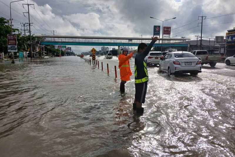
Thailand’s Meteorological Department (TMD) has issued the second warning regarding Tropical Storm Bualoy, forecasting heavy rainfall across regions in Thailand, including Bangkok, with an 80% chance of precipitation.
Affected today, September 27, are 47 provinces, with intense rain expected in the northeast and eastern regions, particularly in provinces such as Phitsanulok, Phetchabun, Loei, Nong Bua Lamphu, Udon Thani, Chaiyaphum, Khon Kaen, Nakhon Ratchasima, Buriram, Chanthaburi, and Trat. The northern and central regions, including Bangkok and nearby areas, will also experience heavy rainfall in certain areas.
Residents in upper Thailand are urged to be cautious of potential dangers from heavy rain and accumulated precipitation, which may lead to flash floods, forest run-off, and overflowing rivers, especially in mountainous areas, lowlands, and flood-prone regions. The TMD reports that three regions could experience 80% heavy rainfall, with 52 provinces expected to be affected.
The strong monsoon trough over lower northern and northeastern Thailand, combined with a moderate southwest monsoon covering the Andaman Sea, Thailand, and the Gulf of Thailand, contributes to moderate to strong wind and wave activity. The upper Andaman Sea could see waves reaching 2 metres, and in stormy conditions, waves might exceed 2 metres. The lower Andaman Sea and upper Gulf of Thailand are expected to have waves ranging from 1 to 2 metres, with stormy waves reaching approximately 2 metres. Mariners are advised to exercise caution and avoid areas with thunderstorms.
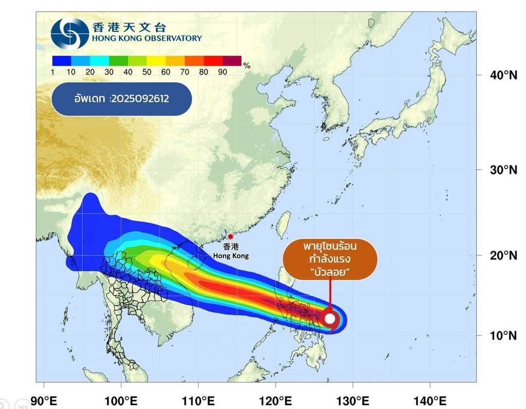
Tropical Storm Bualoy, currently in the central South China Sea, is anticipated to make landfall in northern Vietnam between tomorrow, September 28 and Monday, September 29.
Forecasts for Thailand from 6am today to 6am tomorrow indicate thunderstorms over 70% of the northern region, with heavy rain in areas such as Chiang Mai, Lamphun, Lampang, Phrae, Sukhothai, Uttaradit, Phitsanulok, and Phetchabun. Temperatures will range from 22 to 24°C at night to 3 to 33°C during the day, with variable winds at 10 to 15 km/h.
In the northeast, 80% of the region will experience thunderstorms with heavy to very heavy rain and strong winds in provinces such as Loei, Nong Bua Lamphu, Chaiyaphum, Nong Khai, Udon Thani, Sakon Nakhon, Khon Kaen, Maha Sarakham, Kalasin, Mukdahan, Roi Et, Surin, Sisaket, Nakhon Ratchasima, Ubon Ratchathani, Buriram, Yasothon, and Amnat Charoen. Temperatures will range from 23 to 25°C at night to 29 to 32°C during the day, with variable winds at 10 to 30 km/h.


The central region will see thunderstorms over 70% of the area, with heavy rainfall in Nakhon Sawan, Uthai Thani, Chai Nat, Lopburi, Saraburi, and Kanchanaburi. The temperature will range from 24 to 26°C at night to 32 to 34°C during the day, with southwest winds at 10 to 25 km/h.
In the east, 80% of the area will experience thunderstorms with heavy to very heavy rain in Nakhon Nayok, Prachin Buri, Sa Kaeo, Chachoengsao, Rayong, Chanthaburi, and Trat. Temperatures will range from 23 to 26°C at night to 27 to 32°C during the day, with southwest winds at 15 to 35 km/h. Sea waves will range from 1 to 2 metres, and in stormy conditions, waves will exceed 2 metres.
In southern Thailand on the east coast, 40% of the area will have thunderstorms, mostly in Phetchaburi, Prachuap Khiri Khan, Chumphon, and Surat Thani. Temperatures will range from 23 to 26°C at night to 32 to 34°C during the day. From Surat Thani upwards, southwest winds will blow at 15 to 35 km/h, with sea waves of 1 to 2 metres and stormy waves reaching approximately 2 metres. From Nakhon Si Thammarat downwards, southwest winds will be at 15 to 30 km/h, with sea waves reaching 1 metre and stormy conditions causing waves to rise to 1 to 2 metres.
On the west coast of southern Thailand, 40% of the area will experience thunderstorms with heavy rain in Ranong and Phang Nga. Temperatures will range from 24 to 27°C at night to 30 to 33°C during the day. From Phuket upwards, southwest winds will blow at 20 to 35 km/h, with sea waves about 2 metres high and exceeding 3 metres in stormy conditions. From Krabi downwards, southwest winds will range from 15 to 35 km/h, with sea waves of 1 to 2 metres and stormy waves reaching approximately 2 metres.
Bangkok and surrounding areas will experience thunderstorms over 80% of the area, with heavy rain in some locations. Temperatures will range from 25 to 26°C at night to 31 to 33°C during the day, with southwest winds at 10 to 25 km/h, reported KhaoSod.
Latest Thailand News


Follow The Thaiger on Google News: