Thailand set for cooler weather returning in February
TMD forecasts warming trends and fog across upper Thailand before a temperature drop on February 1. Read the 7-day weather outlook to prepare for the changing conditions.

Bangkok, 27 January 2026 – The Thai Meteorological Department (TMD) issued a 7-day weather forecast covering January 26 to February 1, 2026. The report indicates fluctuating weather patterns, starting with a warming trend and morning fog before a new cold air mass impacts the country.
From January 26 to 31, upper Thailand and the upper Southern region will experience rising temperatures accompanied by morning fog. Despite the warming trend, cool to cold weather remains in the mornings for the upper North and upper Northeast. This shift results from the weakening of the high-pressure system currently covering upper Thailand and the South China Sea.
A significant change is expected on February 1. Temperatures in upper Thailand will drop, while the Northeast will face strong winds. A new moderate high-pressure area from China will extend to cover upper Thailand and the South China Sea, bringing cooler conditions.
PM2.5 Dust Accumulation Warning
Residents in upper Thailand should remain vigilant regarding health and haze. Between January 26 and 31, poor air circulation and weak winds will lead to increased accumulation of dust particles and smoke haze.
The Southern region will see scattered thunderstorms. A moderate northeast monsoon prevails over the Gulf of Thailand and the Andaman Sea.
Waves in the lower Gulf of Thailand will reach heights of 1-2 meters. The upper Gulf and offshore areas of the Andaman Sea will see waves around 1 meter. In thunderstorm areas, wave heights may exceed 2 meters. All ships should proceed with caution and avoid navigating through stormy areas throughout this period.


Regional Weather Forecast: January 26 – February 1, 2026
Northern Region Cool to cold weather persists with morning fog.
-
Temperature: Minimum 13-20°C, Maximum 29-33°C.
-
Mountain Peaks: Cold to very cold conditions with isolated frost. Minimum temperature 2-12°C.
-
Wind: Easterly winds, 10-15 km/h.
Northeastern Region
-
Jan 26-31: Cool to cold with morning fog. Temperatures will rise by 1-3°C. Minimum 14-23°C, Maximum 29-34°C. Mountain peaks will remain cold to very cold, with lows of 8-14°C.
-
Feb 1: Weather turns cool to cold with strong winds. Temperatures will drop by 1-3°C. Minimum 13-22°C, Maximum 28-33°C. Mountain peaks will see lows of 6-13°C.
-
Wind: Northeasterly winds, increasing to 10-30 km/h on February 1.
Central Region Cool weather with morning fog. Temperatures are expected to rise by 1-2°C.
-
Temperature: Minimum 17-25°C, Maximum 30-34°C.
-
Wind: Easterly winds, 10-15 km/h.
Eastern Region Cool weather with morning fog. Temperatures will rise by 1-3°C.
-
Temperature: Minimum 19-25°C, Maximum 30-34°C.
-
Wind: Easterly winds, 15-30 km/h.
-
Sea: Waves below 1 meter near the shore, rising to 1-2 meters offshore.
Southern Region (East Coast) Cool mornings with thunderstorms in 10-20% of the area throughout the period.
-
Temperature: Minimum 18-25°C, Maximum 29-34°C.
-
Sea Conditions (Surat Thani upwards): Waves approximately 1 meter, rising above 2 meters in storm areas.
-
Sea Conditions (Nakhon Si Thammarat downwards): Waves 1-2 meters, rising above 2 meters in storm areas.
Southern Region (West Coast) Cool mornings with thunderstorms in 10-20% of the area throughout the period.
-
Temperature: Minimum 21-25°C, Maximum 31-34°C.
-
Sea Conditions: Waves approximately 1 meter. Offshore and storm areas will see waves exceeding 1 meter.
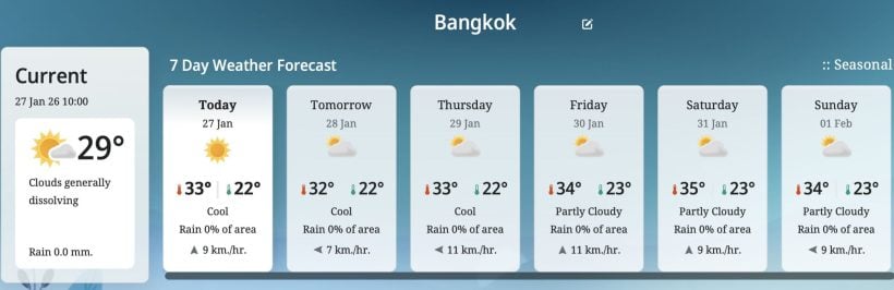
Bangkok and Vicinity Cool weather with morning fog. Temperatures will rise by 1-3°C.
-
Temperature: Minimum 22-25°C, Maximum 31-34°C.
-
Wind: Easterly winds, 10-15 km/h.
Latest Thailand News


Follow The Thaiger on Google News: