Cool winds up north, flash floods lash Thailand’s south
Temperature drops, strong winds, and stormy seas spark warnings

Thailand braces for shifting weather as cool winds sweep northern Thailand and storms pound the southern regions, prompting flood and marine warnings.
A high-pressure system from China is sweeping across upper Vietnam and is expected to reach Laos and northeastern Thailand today. This will bring cooler mornings and strong winds to the north and northeast, with a slight dip in temperatures and minimal rainfall.
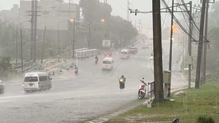
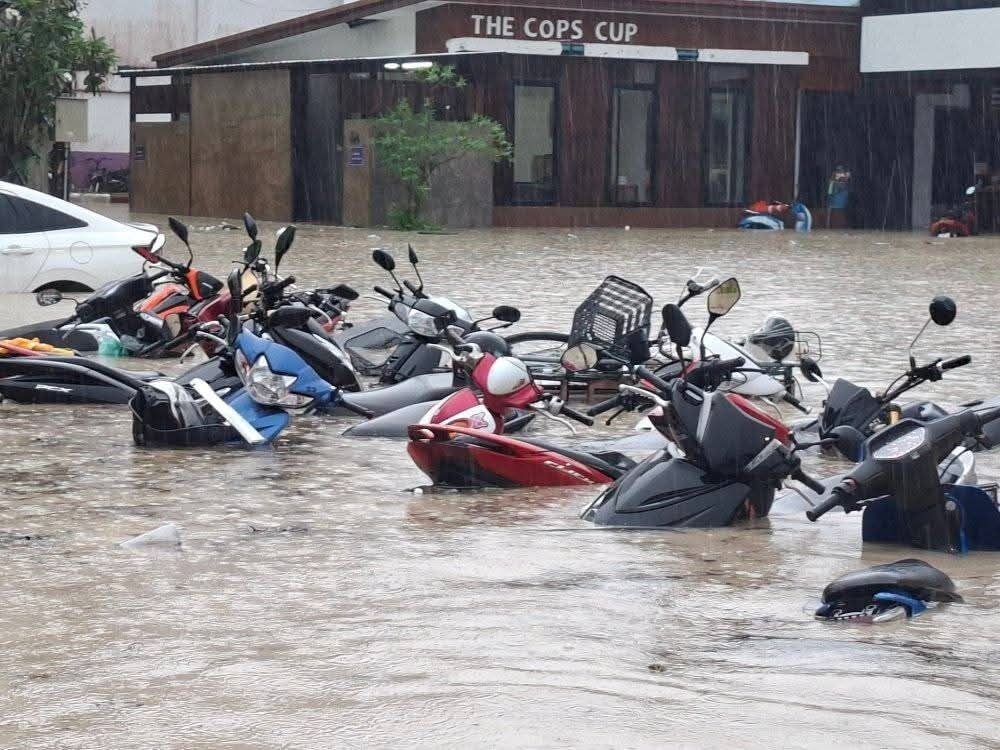
In contrast, the South is facing isolated heavy downpours, especially along the Gulf and Andaman coasts. The Meteorological Department (TMD) warns of possible flash floods and water overflows in foothill and low-lying areas. Residents are urged to stay cautious.
Winds and waves are expected to reach around 1 metre, climbing to over 2 metres during storms. All vessels should steer clear of stormy zones.
Meanwhile, tropical storm Fengshen is gathering strength over the upper South China Sea. The system is forecast to approach southern Hainan and Vietnam’s central coast tomorrow, October 22 to Thursday, October 23, before weakening due to the advancing high-pressure front. The storm poses no threat to Thailand.
The weather forecast from 6am today, October 21, to 6am tomorrow, October 22, is as follows:
In northern Thailand, expect cool mornings with a slight temperature drop. Isolated thundershowers are likely in Mae Hong Son, Tak, and Kamphaeng Phet. Minimum temperatures range from 20 to 23°C, with highs reaching 32 to 35°C. Easterly winds will blow at 5 to 15 km/h.


The Northeast will see a temperature drop of 1 to 2°C alongside strong winds. Lows will hover around 20 to 24°C and highs around 31 to 33°C. Northeasterly winds will reach 15 to 30 km/h.
In the central region, expect isolated showers, mainly in Kanchanaburi, Suphan Buri, Ratchaburi, and Samut Songkhram. Temperatures will range from 23 to 25°C at the low end and 32 to 35°C at the high. Easterly winds will hit 10 to 20 km/h.
Eastern provinces such as Chachoengsao, Chon Buri, Rayong, Chanthaburi, and Trat can also expect isolated thundershowers. Temperatures will range from 24 to 25°C in the morning to 33 to 36°C in the afternoon. Winds will blow from the east at 15 to 30 km/h. Sea levels are expected to be around 1 metre and over 2 metres during storms.
On the east coast in the south, including Prachuap Khiri Khan, Chumphon, Surat Thani, Nakhon Si Thammarat, Phatthalung, Songkhla, Pattani, Yala, and Narathiwat, will face widespread showers and isolated heavy rain. Minimum temperatures will range from 23 to 25°C, with highs from 31 to 34°C. Easterly winds will blow at 15 to 30 km/h and waves will reach over 2 metres in storms.
The southern west coast, including Phuket, Krabi, Trang, and Satun, will also see widespread rain. Lows will hover between 23 to 25°C, while highs will range from 30 to 33°C. Expect similar wind speeds and sea conditions as the east coast, the TMD says.
In Bangkok and surrounding areas, isolated thundershowers are expected. Temperatures will sit between 25 to 26°C in the morning and 34 to 35°C during the day. Easterly winds will range from 10 to 20 km/h.
Latest Thailand News


Follow The Thaiger on Google News: