Storm brews near Thailand as rain and rough seas roll in
Coastal areas urged to stay alert as waves exceed 2 metres

Thailand is bracing for scattered rain, strong winds, and choppy seas as shifting monsoon patterns and a tropical storm nearby stir up regional weather conditions.
The Thai Meteorological Department (TMD) has issued a nationwide weather advisory as an easterly wind system continues to influence the Northeast, the East, and the Gulf of Thailand, while the southwest monsoon remains weak over the Andaman Sea and southern regions. Although rainfall is expected to be less widespread, isolated heavy showers may still occur, especially near foothills, waterways, and low-lying areas. Mariners are also urged to remain cautious, as thundershowers could generate hazardous sea conditions.
The forecast for 6pm yesterday, October 2, to 6pm today, October 3, is as follows:
In the North, scattered thundershowers are expected, particularly in Mae Hong Son, Chiang Mai and Tak provinces. Minimum temperatures will range between 22 to 25°C, while maximum temperatures will climb to 31 to 34°C. Winds will be variable, blowing at speeds of 10 to 20 km/h.
The Northeast will see isolated thundershowers, mainly affecting areas such as Loei, Chaiyaphum, Nakhon Ratchasima, Buriram and Surin. Temperatures are forecast to dip to 22 to 25°C at night and rise to 33 to 35°C during the day. Easterly winds will prevail at 10 to 20 km/h.
Central Thailand is forecast to experience scattered thundershowers with isolated heavy rain in provinces including Nakhon Sawan, Uthai Thani and Kanchanaburi. Night-time temperatures will range from 23 to 26 degrees Celsius, with daytime highs reaching 34 to 35°C. Southeasterly winds are expected at speeds of 10 to 20 km/h.
In the East, scattered thundershowers are likely, especially in Rayong, Chanthaburi and Trat. Temperatures will range from 24 to 26°C at night and 32 to 34°C during the day. Easterly winds will blow at 15 to 30 km/h. Offshore, waves are expected to reach around 1 metre, increasing to over 2 metres during thundershowers.


The southern region’s east coast will face isolated thundershowers, particularly in Phetchaburi, Prachuap Khiri Khan, Yala and Narathiwat. Minimum temperatures are expected between 23 and 25°C, with highs of 33 to 34°C. Easterly winds will blow at 15 to 30 km/h, creating waves of approximately 1 metre, with higher surges of over 2 metres in areas affected by storms.
On the west coast, scattered thundershowers and isolated heavy rainfall are forecast in provinces including Krabi, Trang and Satun. Night-time temperatures will fall between 22 and 25°C, while maximum daytime temperatures are expected to reach 32 to 35°C. Southwesterly winds will blow at 15 to 30 km/h. Sea conditions may feature waves of around 1 metre, rising above 2 metres during storm activity.

In the Bangkok Metropolitan Region, scattered thundershowers are expected throughout the forecast period. Minimum temperatures will remain between 25 and 26°C, with highs of 33 to 35°C. Winds will blow from the southeast at 10 to 20 km/h.
Mariners operating in both the Gulf of Thailand and the Andaman Sea are advised to proceed with caution, especially in areas experiencing thundershowers. All small boats should avoid venturing out to sea during periods of heavy rain and high waves.
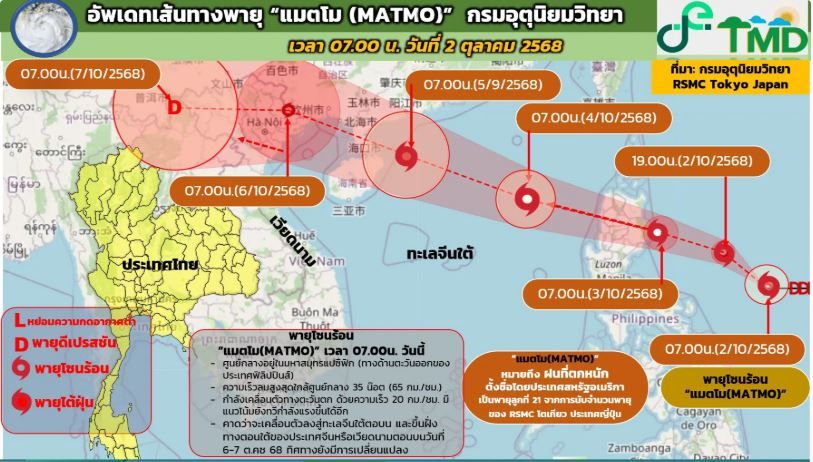
Meanwhile, tropical storm Matmo, currently situated over the eastern Philippines, is expected to move into the South China Sea between October 3 and 4. Forecast models indicate that the storm will make landfall over upper Vietnam around October 5 to 6, according to the TMD.
Officials have confirmed that Matmo will not directly impact Thailand, but they continue to monitor its progress closely.
Residents across all regions are urged to stay updated on local weather developments and take appropriate precautions to ensure their safety.
Latest Thailand News


Follow The Thaiger on Google News: