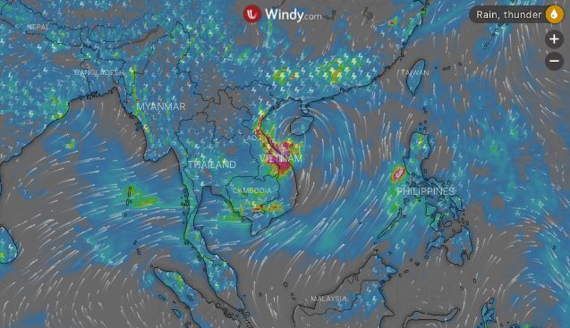
Podul plods towards Vietnam’s coast and will bring rain to northern Thailand over weekend

Tropical storm Podul is still moving towards Việt Nam with the eye of the storm sitting to the south-west under China’s Hainan island, in the north of the South China Sea this afternoon. It is slowly moving westward towards Vietnam’s northern central coast.
Vietnam’s Deputy Prime Minister says the storm will cross the coast tomorrow and cross the country into Laos during the National Day holidays “so it was necessary for tourists to pay attention to weather forecasts”.
The storm was expected to make landfall on Friday afternoon or night together with a rising tide, causing difficulties for coastal responders.
Nguyễn Xuân Cường, Vietnamese minister of Agriculture and Rural Development, says areas forecast to have heavy rain were the northern mountainous provinces, the Red River Delta, the north-central region and the Central Highlands.
“If heavy rains continued to occur in these areas, it was necessary to prepare for flash floods and landslides.”
Meanwhile in Thailand, cutting through a lot of media brouhaha on Podul, the remnants of the storm, as it weakens, after crossing Vietnam’s coast and moving westwards, is likely bring some rain to parts of the north and the upper parts of north-east Thailand, but nothing beyond heavy rains is forecast.
Meanwhile, there are warnings out for the Andaman coast where moisture and wind are being sucked up from the Indian ocean and may bring rain and strong winds to coastal regions including Ranong, Phang Nga, Phuket, Krabi and southern west-coast beaches over the next three days.
The official warning from the Thai Meteorological Department follows….
Tropical Storm “PODUL”category 3 moved was centered about 300 kilometers of the northeast of Danang, Vietnam or at latitude 17.5 degrees north, longitude 110.8 degrees east having maximum sustained wind of 80 km/hr. At a speed of about 25 km/hr, it is moving westward and expected to make landfall over upper Vietnam by tomorrow (30 August 2019). This storm is forecast to downgrade to tropical depression. More rains likely while torrential rains and strong winds will effect on the Northeast at the first, then the North, the East and the South. People should brace for the severe conditions that may cause flash flood.
Affected areas are as following:
29 August 2019, heavy to very heavy rains…
North: Chaing Rai, Lampang, Phayao, Phrae, Nan, Uttaradit, Phitsanulok and Phetchabun.
Northeast: Bueng Kan, Nong Khai, Udon Thani, Nong Bua Lamphu, Nakhon Phanom, Sakon Nakhon, Mukdahan, Amnat Charoen, Yasothon, Kalasin, Roi Et, Nakhon Ratchasima, Buri Ram, Surin, Si Sa Ket and Ubon Ratchathani.
Central: Nakhon Sawan, Chai Nat, Ang Thong, Sing Buri, Lop Buri and Saraburi.
East: Nakhon Nayok, Prachin Buri, Sa Kaeo, Chanthaburi and Trat.
South: Ranong, Phangnga, Phuket, Krabi, Trang and Satun.
August 30-31 2019, heavy to very heavy rains…
North: Chiang Mai, Chiang Rai, Phayao, Phrae, Nan, Lamphun, Lampang, Tak, Sukhothai, Kamphaeng Phet, Uttaradit, Phitsanulok, Phichit and Phetchabun.
Northeast: Loei, Nong Bua Lam Phu, Udon Thani, Nong Khai, Bueng Kan, Sakon Nakhon, Nakhon Phanom, Mukdahan, Yasothon, Kalasin, Khon Kaen, Chaiyaphum, Nakhon Ratchasima, Maha Sarakham, Roi Et, Amnat Charoen, Buri Ram, Surin, Si Sa Ket and Ubon Ratchathani.
Central: Kanchanaburi, Uthai Thani, Suphan Buri, Chai Nat and Nakhon Sawan.
East: Nakhon Nayok, Prachin Buri, Chachoengsao, Sa Kaeo, Chon Buri, Rayong, Chanthaburi and Trat.
South: Phetchaburi, Prachuap Khiri Khan, Chumphon, Ranong, Phangnga, Phuket, Krabi, Trang and Satun.
1 September 2019, heavy rain…
North: Mae Hong Son, Chiang Mai, Lamphun, Lampang, Tak, Sukhothai and Kamphaeng Phet.
Central: Ratchaburi, Kanchanaburi, Uthai Thani, Suphan Buri and Chai Nat.
East: Chon Buri, Rayong, Chanthaburi and Trat.
South: Phetchaburi, Ranong, Phangnga and Phuket.
Latest Thailand News
Follow The Thaiger on Google News:


