Chiang Mai
The end of the annual crop-burning season – Chiang Mai gets some fresh air

As the annual crop season in north Thailand comes to an end the only good side-effect of the whole Covid-19 outbreak is a drop in the number of fires and plantation burning activity in the past few months.
As a result, Chiang Mai’s Air Quality has experienced significant improvements, according to aqicn.org.
The website data shows that Chiang Mai air quality index reported PM2.5 levels of less than 100 particles per cubic metre for more than two weeks. 50 AQI is the general safety standard in Thailand (and 25 for the World Health Organisation upper limit of safe air quality. On some days in the middle of the highest readings the AQI reached about 500!
The AQI is a standard that indicates the level of air pollution.
• Level 0-50 means good air quality
• 51-100 means moderate quality
• 101-105 will affect sensitive groups
• 151-200 is slightly harmful to health
• 201-300 is highly harmful
• 301-500 means extremely dangerous
For several days in the past two weeks, Chiang Mai’s air quality index has seen a decrease of more 50%, compared to the AQI levels at the same time in 2019. For two days in a row the northern city scored dubious distinction of having the world’s worst air quality.
April 30
2019 – Air Quality Index of 152 | 2020 – Air Quality Index of 57
May 4
2019 – Air Quality Index of 158 | 2020 – Air Quality Index of 56
May 12
2019 – Air Quality Index of 129 | 2020 – Air Quality Index of 69
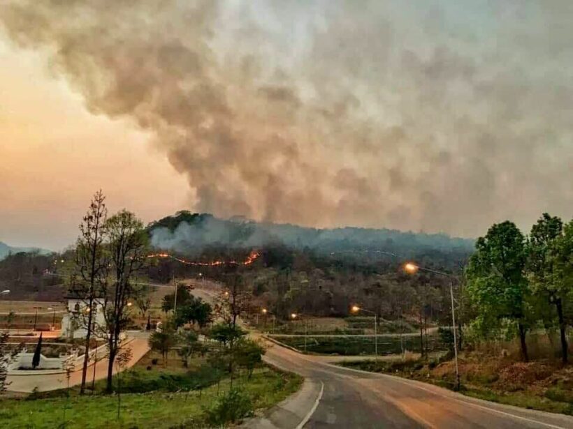
Smog, smoke and haze have been a widespread public health problem in North & Central Thailand for over a decade. It typically occurs from January to April, but peaks in March as very dry conditions intensify the forest fires. It’s exacerbated by farmers who burn plantation waste to clear land for the next harvest season.
SOURCE: Samui Times
Keep in contact with The Thaiger by following our Facebook page.
Never miss out on future posts by following The Thaiger.
Air Pollution
59 areas see excessive PM 2.5 dust in Bangkok today

59 areas in Bangkok are seeing excessive PM 2.5 dust ratings today as air quality is being described as moderate to poor. Din Daeng Road is being identified as the most polluted, according to the air4thai website of the Pollution Control Department. The amount of PM 2.5 dust is being measured at between 39 and 113 microns.
Din Daeng is also joining Bang Na-Trat highway in Bang Na district, Lat Phrao district and Sukhapibaan 5 Road in Sai Mai district in featuring PM10 dust in the atmosphere that is measuring between 54 and 155 microns.
Read more about Bangkok’s pollution today, and its causes, HERE.
The 59 areas that are considered polluted today are:
Hirunrujee sub-district, Thon Buri district
Kanchanapisek Road in Bang Khun Thian district
Bang Na sub-district
Song Khanong sub-district in Phra Pradaeng district
Din Daeng sub-district, Din Daeng district
Talat Kwan sub-district in Muang district of Nonthaburi
Omnoi sub-district in Krathumban district of Samut Sakhon
Paknam sub-district in Muang district of Samut Prakan
Bang Sao Thong sub-district
Khlong 1 sub-district in Khlong Luang district of Pathum Thani
Rama 4 Road in Pathumwan district
Intharapitak Road in Thon Buri district
Lat Phrao Road in Wang Thong Lang district
Din Daeng Road in Din Daeng district
Khlong Goom sub-district
Khlong Sam Wa district
Chom Thong district
Charunsanitwong Road in Bang Phlad district
Rama 2 Road in Bang Khun Thian district
Vibhavadi Rangsit highway in Din Daeng district
Sukhumvit Road in Phra Khanong district
Ratburana Road in Ratburana district
Rama 5 Road in Dusit district
Trimitr Road at Wongwian Odeon, Samphanthawong district
Rama 6 Road in Phya Thai district
Lat Phrao Road at Soi Lat Phrao 95 in Wang Thong Lang district
Rama 4 Road in front of Sam Yan Mitrtown, Pathumwan district
Narathiwat Road in Bang Rak district
Thung Wat Don sub-district
Rama 3-Charoen Krung Road in Bang Khor Laem district
Sukhumvit Road Soi 63 in Wattana district
Pattanakarn Road in Suan Luang district
Bang Na-Trat highway in Bang Na district
Pahonyothin Road at Kasetsart intersection, Chatuchak district
Don Mueang district
Sukhapibaan 5 Road in Sai Mai district
Nawamin Road in Bang Kapi district
Suan Sayam-Raminthra intersection in Kanna Yao district
Lat Krabang Road in Lat Krabang district
Seehaburanakit Road in Min Buri district
Liab Waree Road in Nong Chok district
Srinakharin Road in Prawet district
Ratchadapisek-Tha Phra Road in Thon Buri district
Charoen Nakhon Road in Khlong San district
Tha Phra intersection, Bangkok Yai district
Soi Nikhom Rodfai Thon Buri in Bangkok Noi district
Buddha Monthon 1 Road in Taling Chan district
Thawee Wattana Road in Thawee Wattana district
Aekkachai Road in Bang Bon district
Pracha-uthit Road in Thung Khru district
Samsen Road in Phra Nakhon district
Huay Khwang district
Khlong Toey sub-district
Ban Sue sub-district
Lat Phrao district
Thung Song Hong sub-district
Pahonyothin Road in Bang Khen district
Saphan Soong district
SOURCE: Thai PBS World
Keep in contact with The Thaiger by following our Facebook page.
Never miss out on future posts by following The Thaiger.
Environment
Thailand on fire – NASA satellite website tracks the country’s farm fires

Thailand is burning. The burning off of harvested crop plantations is lighting up the agricultural areas. The truth is starkly revealed in the live NASA satellite feeds which track the fires around the world.
CHART: Fires in the past 10 days around parts of Thailand – Firms.Modaps
Concentrations of the current fires can be seen in Central Thailand, north of Bangkok, parts of Isaan, north east of Bangkok, and around Chiang Mai in Northern Thailand. Notably the concentration of fires in northern Cambodia and across the north-western border in Myanmar, is also causing plenty of problems as the foreign smoke drifts across the borders. No matter what Thai officials do to enforce the rice, sugar and corn plantation burn-offs, there is little they can do about the haze drifting across the borders.
Bangkok, so close to clusters of fires, is in for a bad air pollution day anytime the light winds of the start of the year blow from the north or the east. The lack of rain adds to the problem, the annual problem, that engulfs Thailand’s capital during days between December and April, with the worst month, statistically, being March.
The alternative method of preparing for the next harvest, mechanical removal of the refuse and waste after harvesting, is both unpopular in Thailand and economically unviable for the small farmers whose margins remain thin with the multi-national buyers of their produce pushing for lower and lower prices every year.
In Chiang Mai, from January to the end of March, the locals even call it the ‘burning season’. Coupled with the hot season, the farmers in northern Thailand burn their fields to prepare land for the next harvest and also to get rid of biowastes like corn that can’t be sold in the market. It’s officially illegal to do the burn offs but the lack of enforcement leaves the problem unresolved and the smog and haze remain as predictable as the annual wet season.
Chiang Mai also has a local geographic problem which exacerbates the bad smoke pollution. The city is in a valley, surrounded by hills, trapping in the smoke and helping block any breezes that could otherwise blow it away.
For today, Bangkok’s air pollution is better than the past two days but still registering as ‘unhealthy for sensitive groups’ with city readings mostly between 140 – 170. Parts of the city, mostly south-east and south west, were registering readings above 300 in the past few days.
SOURCE: IQair.com
Watch this video for some more information about Bangkok’s smog…
Keep in contact with The Thaiger by following our Facebook page.
Never miss out on future posts by following The Thaiger.
Air Pollution
Bangkok’s air quality is ‘unhealthy’ today | VIDEO

Air quality around Bangkok this morning is awful. Partly due to the lack of wind to blow the smog out of the area. To the south of Bangkok, Samut Prakan and Samut Sakhon, the air quality is even worse with visibility on the ground cut to less than a kilometre. You would be well advised to reduce you activities outside on a day of high air pollution in the capital. The rating by airvisual.com is ‘unhealthy’.
Readings around the inner city vary between 190 – 220. Areas to the east, including around Suvarnabhumi Airport, are higher.
A lot of the smog and smoke is flowing down from the north and north east where plantation fires rage, mostly unenforced, this time of the year, from December to May. Farmers have been told, repeatedly, to avoid buying off the waste after harvests of corn, rice and sugar cane but officials have been disinclined to enforce the laws. Many of the farmers have long-term contracts with some of Thailand’s leading agri-business conglomerates.
Bangkok and the central region can expect many more months, especially as the temperatures rise throughout February, March and April and the winds remain low as the north-easterly monsoon weakens.
PHOTO: View across the Bangkok skyline from Sathorn this morning.
Keep in contact with The Thaiger by following our Facebook page.
Never miss out on future posts by following The Thaiger.
- Thailand3 days ago
Thailand to introduce 300 baht “tourism fee” to insure foreign visitors, manage tourist destinations
- Coronavirus (Covid-19)3 days ago
Covid-19 measures and safety restrictions to be reviewed at the end of the month
- Chon Buri4 days ago
Chon Buri announces a list of 2 Covid-19 hotspots, visitors are urged to get a virus screening
- Crime3 days ago
Koh Samui senior police officer faces charges for allegedly raping a suspect
- Coronavirus (Covid-19)3 days ago
At least 33 police officers, officials, implicated in migrant smuggling operation
- Bangkok1 day ago
BTS skytrain maximum fare rate increasing to 158 baht despite backlash
- Central Thailand3 days ago
Student arrested in dormitory at night, charged with lèse majesté offences
- Coronavirus (Covid-19)1 day ago
Thailand threw a tourism party. No one arrived.