“Pabuk” heads towards southern provinces

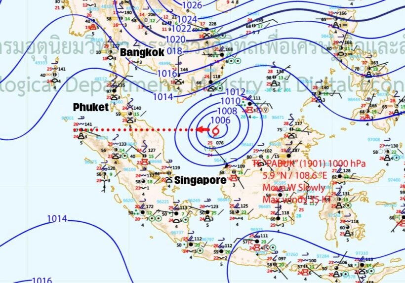
An unseasonal, and quite unusual, tropical depression is heading towards southern shores including all Thai provinces south of Phetchaburi. The Thai Meteorological Department is issuing regular warnings about the storm’s progress from the South China Sea and into the southern Gulf of Thailand.
“On 2 January 2019, tropical storm “PABUK” over the lower South China Sea located at latitude 6.0 degree north, longitude 108.0 degree east with maximum sustained winds of 65 km/hr. The storm is moving west at a speed of 10 km/hr through the tip of Indochina expectedly to the lower Gulf of Thailand by January 2-3 2019. By January 3-5 , it will affect the South with more rain and some torrential downpours. People should beware of the severe conditions. Affected areas are as followings:
January 3-4
Isolated torrential downpours with strong wind in Surat Thani, Nakhon Si Thammarart, Phatthalung, Songkhla, Pattani, Yala, Narathiwat, Krabi, Trang and Satun.
January 4-5
Isolated torrential downpours with strong wind in Phetchaburi, Prachuap Khiri Khan, Chumphon, Surat Thani, Nakhon Si Thammarart, Phatthalung, Songkhla, Pattani, Yala, Narathiwat, Ranong, Phangnga, Phuket, Krabi, Trang and Satun.
The strong winds are forecast for both the Gulf of Thailand and Andaman Sea with waves up to 3-5 metres high in the Gulf and 2-3 metres in the Andaman Sea. People in the Gulf should be aware of inshore surges. All ships should keep ashore until January 5, 2019.
Keep up-to-date with the latest 2019 Pabuk storm coverage on The Thaiger.
Latest Thailand News
Follow The Thaiger on Google News:


