Monsoon rains to hit 44 Thai provinces, severe downpours

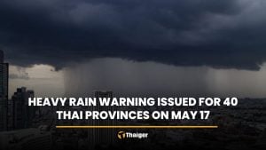
Heavy monsoon rains are expected to batter 44 provinces across Thailand today, with two regions facing severe downpours covering 70% of their areas. Residents are urged to be cautious of flash floods and forest runoff.
The Thai Meteorological Department (TMD) forecasts that over the next 24 hours, a monsoon trough will move across the upper northern and upper northeastern regions, extending into a low-pressure system over the central South China Sea. Additionally, a moderate southwesterly monsoon will cover the Andaman Sea, Thailand, and the Gulf of Thailand.
This weather pattern is likely to result in increased rainfall across the country, with some areas experiencing heavy rain. People in these regions should be aware of the dangers posed by heavy and accumulated rainfall, which could lead to flash floods and forest runoff.
In the Andaman Sea, moderate winds will create waves about 2 metres high, while the lower Andaman Sea and upper Gulf of Thailand will see waves of 1 to 2 metres. Areas experiencing thunderstorms could see waves higher than 2 metres, prompting sailors to exercise caution and avoid sailing in stormy conditions.
Between tomorrow and September 6, the monsoon trough is expected to move across the northern, central, and northeastern regions of Thailand, entering a strong low-pressure system over the central South China Sea. The moderate southwesterly monsoon will continue to cover the Andaman Sea, southern, and eastern regions, and the Gulf of Thailand.
This will lead to heavy rainfall in some areas, particularly in the lower northern, lower northeastern, and central regions, including Bangkok and its vicinity, eastern and southern regions. The Andaman Sea and the Gulf of Thailand will see stronger winds, with waves in the Andaman Sea reaching 2 to 3 metres and exceeding 3 metres in stormy areas. The upper Gulf of Thailand will have waves about 2 metres high, with higher waves in areas of thunderstorms.
The Shanshan tropical storm currently covers the southern region of Kansai, Japan. Those planning to travel to this area should check the weather conditions before departure.


Heavy rain
Northern region: thunderstorms affecting 60% of the area, with heavy rain in Mae Hong Son, Chiang Mai, Chiang Rai, Lampang, Phayao, Nan, Uttaradit, Phitsanulok, Tak, and Phetchabun. Temperatures will range from 24 to 26 degrees Celsius in the morning and rise to 31 to 36 degrees Celsius during the day. Southwesterly winds will blow at speeds of 10 to 15 kilometres per hour.
Northeastern region: thunderstorms are expected in 70% of the area, with heavy rain in Loei, Nong Khai, Bueng Kan, Nong Bua Lam Phu, Udon Thani, Sakon Nakhon, Nakhon Phanom, Mukdahan, Yasothon, Amnat Charoen, Ubon Ratchathani, Chaiyaphum, and Nakhon Ratchasima. Temperatures will range from 24 to 26 degrees Celsius in the morning and peak at 32 to 34 degrees Celsius. Southwesterly winds will blow at speeds of 10 to 20 kilometres per hour.
Central region: thunderstorms affect 60% of the area, with heavy rain in Lopburi, Saraburi, Kanchanaburi, and Ratchaburi. Morning temperatures will be between 23 and 26 degrees Celsius, rising to 34 to 36 degrees Celsius in the afternoon. Southwesterly winds will blow at speeds of 10 to 20 kilometres per hour.
Eastern region: thunderstorms covering 70% of the area, with heavy rain in Nakhon Nayok, Chachoengsao, Prachinburi, Sa Kaeo, Rayong, Chanthaburi, and Trat. Temperatures will range from 23 to 27 degrees Celsius in the morning, rising to 31 to 35 degrees Celsius. Southwesterly winds will blow at speeds of 15 to 35 kilometres per hour. The sea will have waves of 1 to 2 metres, rising higher than 2 metres in stormy areas.
Southern region (east coast): thunderstorms affecting 30% of the area, mainly in Phetchaburi, Surat Thani, Nakhon Si Thammarat, Songkhla, Yala, and Narathiwat. Morning temperatures will range from 23 to 26 degrees Celsius, with daytime temperatures between 33 and 36 degrees Celsius.
Southwesterly winds will blow at speeds of 15 to 35 kilometres per hour from Surat Thani upwards, with waves of 1 to 2 metres, rising higher than 2 metres in stormy areas. From Nakhon Si Thammarat downwards, southwesterly winds will blow at speeds of 15 to 30 kilometres per hour, with waves about 1 metre high, rising higher than 2 metres in stormy areas.
Southern region (west coast): thunderstorms are expected in 40% of the area, mainly in Ranong, Phang Nga, and Phuket. Morning temperatures will range from 24 to 26 degrees Celsius, with daytime temperatures between 31 and 34 degrees Celsius.
Southwesterly winds will blow at speeds of 20 to 35 kilometres per hour from Ranong upwards, with waves about 2 metres high, rising higher than 2 metres in stormy areas. From Phang Nga downwards, southwesterly winds will blow at speeds of 15 to 35 kilometres per hour, with waves of 1 to 2 metres, rising higher than 2 metres in stormy areas, reported KhaoSod.
Bangkok and its vicinity: thunderstorms are expected in 60% of the area, with heavy rain in some areas. Temperatures will range from 26 to 28 degrees Celsius in the morning, rising to 33 to 35 degrees Celsius. Southwesterly winds will blow at speeds of 10 to 20 kilometres per hour.
Latest Thailand News


Follow The Thaiger on Google News: