Four routes under consideration for Koh Chang Bridge
The Expressway Authority of Thailand (EXAT) has initiated a series of public hearings regarding the proposed bridge connecting the mainland to Koh Chang Island, a popular destination in Trat province. The first hearing, held today, September 2, in Mueang district, garnered widespread support from locals and business owners.
Participants expressed a strong preference for the bridge to guide travellers through the Mueang district, emphasising the potential economic benefits of this business hub in eastern Thailand. Two of the proposed routes align with this request, which would facilitate increased commerce and tourism in the area.
Additionally, attendees advocated for a lower bridge toll compared to current ferry fares, the inclusion of lanes for motorcycles and bicycles, and scenic viewpoints at both ends of the bridge. EXAT representatives acknowledged these suggestions and confirmed that the bridge’s design would consider economic growth for Trat’s marquee island.
EXAT Deputy Governor Katpachon Udomthampakdee highlighted that the bridge would enhance accessibility for both visitors and Koh Chang residents, improving travel to essential services such as schools and hospitals on the mainland. Trat Governor Nathapong Sa-nguanchit assured that local stakeholders are fully supportive of the project.
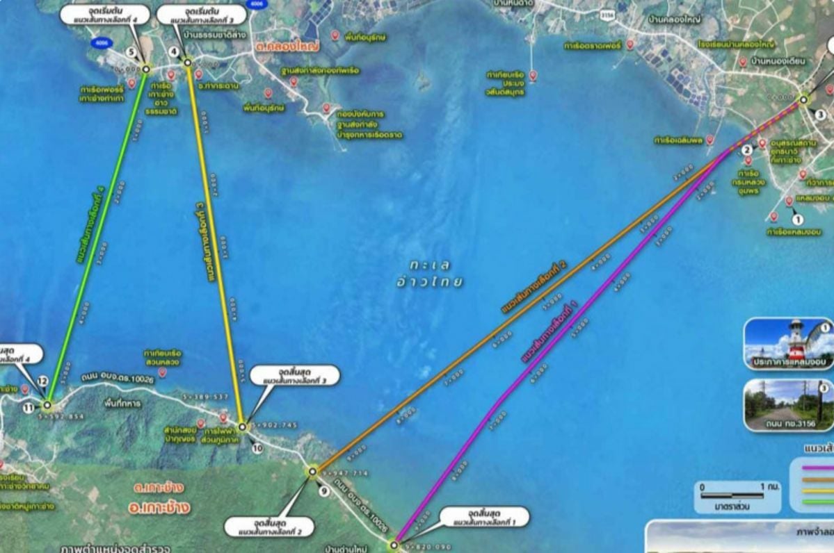
The four proposed bridge routes involve several potential starting points on the mainland and the island.
The first route is proposed to start at the 0.85-kilometre marker on Highway 3156 in Ban Nong Prue village, Laem Ngop district, this 9.82-kilometre route would connect to the island at the 8.55-kilometre marker on Road 10026 in Ban Dan Mai.
The second route, also beginning at the 0.85-kilometre marker on Highway 3156, this 9.95-kilometre route would land at the 6.75-kilometre marker on Road 10026 in Ban Dan Mai.


The third route is proposed to start at the 2.84-kilometre marker on Road 4006 in Ban Thammachat Lang, Laem Ngop district, the 5.90-kilometre route would reach the island at the 5.30-kilometre marker on Road 10026 in Ban Dan Mai.
The final route is proposed to begin at the 3.50-kilometre marker on Road 4006 in Ban Thammachat Lang, this 5.59-kilometre route would land at the 1.90-kilometre marker on Road 10026 in Ban Khlong Son.
All four routes are proposed to be elevated, ensuring sufficient clearance for maritime traffic, and will be constructed to minimise environmental impact on the coral and seagrass around Koh Chang. Construction is scheduled to commence in 2029, with the bridge expected to open in 2033, reported Bangkok Post.
Latest Thailand News


Follow The Thaiger on Google News: