Storm alert: Thundershowers and rough seas hit Thailand
Meteorological Department urges caution as sea conditions worsen and rain spreads

The Thai Meteorological Department (TMD) has warned that southeasterly and easterly winds continue to prevail across Thailand, the Gulf of Thailand and the Andaman Sea, fuelling widespread thundershowers and the threat of isolated heavy rain, particularly in the South.
The northern and central provinces, along with the northeast, are expected to experience scattered thunderstorms. While these are not forecast to be severe, officials have urged the public to take caution, particularly in areas prone to flooding and water accumulation. Residents are advised to avoid travelling through regularly flooded zones during downpours.
At sea, things are looking equally turbulent. Wind speeds in both the Andaman Sea and the Gulf are pushing waves up to about 1 metre in height, climbing to over 2 metres in stormy areas. The TMD has urged all ships to proceed with caution and avoid zones where thunderstorms are active.
Meanwhile, a tropical depression east of the Philippines has intensified into Tropical Storm Fengshen. The storm is projected to pass over the northern Philippines and enter the upper South China Sea between today, October 18, and tomorrow, October 19. It is expected to approach Hainan, China between October 21 and 22. However, Fengshen is forecast to weaken rapidly and is not expected to affect Thailand.

The weather forecast for 6am today to 6am tomorrow is as follows:
Northern Thailand
Scattered thundershowers are expected, especially in Mae Hong Son, Chiang Mai, Lamphun, Tak, Sukhothai, Kamphaeng Phet, Phichit, Phitsanulok, and Phetchabun. Temperatures will range from 22 to 24°C at the lowest, climbing to 32 to 34°C during the day. Winds from the southeast will blow at 5 to 15 km/h.


Northeastern region
Chaiyaphum, Khon Kaen, Nakhon Ratchasima, Buriram, Surin, Sisaket, and Ubon Ratchathani will see isolated thundershowers. Lows will hover around 23 to 24°C, while highs are forecast between 33 and 35°C. Easterly winds will reach speeds of 10 to 20 km/h.
Central region
Expect scattered thundershowers across Kanchanaburi, Ratchaburi, Nakhon Pathom, Samut Songkhram, and Samut Sakhon. Temperatures will dip to 23 to 26°C and rise to 33 to 35°C. Southeasterly winds will sweep through at 10 to 20 km/h.
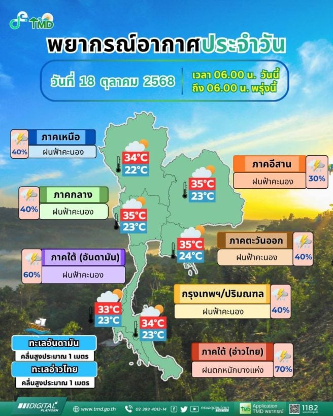
Eastern Thailand
Chachoengsao, Chon Buri, Rayong and Trat will see scattered thundershowers. Morning temperatures will sit between 24 and 25°C, reaching daytime highs of 34 to 35°C. Easterly winds will range from 15 to 30 km/h. Seas will be rough, with waves about 1 metre, rising above 2 metres during thundershowers.
Southern Thailand’s east coast
Fairly widespread thundershowers and isolated heavy rain are forecast in Chumphon, Surat Thani, Nakhon Si Thammarat, Phatthalung, and Songkhla. Lows are set between 23 and 25°C, while highs may reach 32 to 34°C. Southeasterly winds will blow at 15 to 30 km/h, with sea waves around 1 metre and over 2 metres during storms.
West coast
Scattered thundershowers are expected in Phuket, Krabi, Trang, and Satun. Morning lows will be between 23 and 25°C, rising to 31 to 33°C during the day. Southeasterly winds will range from 15 to 30 km/h, bringing seas of about 1 metre, increasing in stormy weather, according to TMD.
Bangkok Metropolitan region
Scattered thundershowers are expected throughout the capital. Morning temperatures will be 24 to 26°C, peaking at 34 to 35°C in the afternoon. Southeasterly winds will reach 10 to 20 km/h.
Latest Thailand News


Follow The Thaiger on Google News: