Heavy rains, severe weather predicted for the south and east
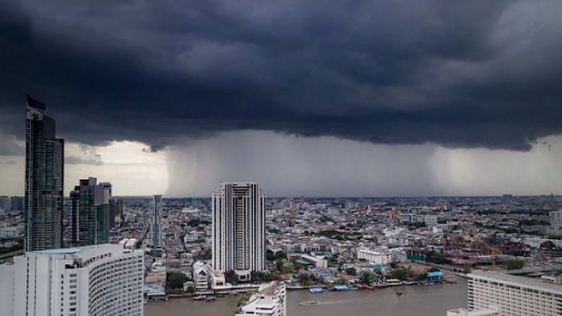
Thailand’s worst drought in 40 years is officially over, as Thailand’s Meteorological Department today predicted continuous rains for the entire country with flash floods possible in the East and South. A low pressure cell is covering Myanmar’s Bay of Martaban while the southwest monsoon across the Andaman Sea and Thailand is growing stronger.
The department predicts continuous rain over Thailand and isolated heavy rain in the East and the South (west coast).
“People in these areas should beware of rain storms that may include flash floods. Winds and waves in the Andaman Sea and the Gulf of Thailand will strengthen from tomorrow to Wednesday, with waves about 2 metres high and higher during thundershowers. All ships in the Andaman Sea from Phuket northward should proceed with extreme caution and avoid thundershowers.”
Cloudy skies are forecast for Bangkok with scattered thundershowers. Minimum temperature will be around 26-27°C and maximum temperature 33-37°C. Southwesterly winds will blow at 10-20 kilometres per hour.
From today through Friday the low pressure cell covering the Gulf of Martaban will intensify and move to the upper Bay of Bengal.
People in volatile areas should beware of severe conditions that may cause flash floods throughout the period. During June 7-11, all ships in the Andaman Sea should proceed with caution and avoid sailing into thundershowers.
Here is the forecast for the next 24 hours:


North
Cloudy with scattered thundershowers, mostly in Mae Hong Son, Chiang Mai,
Lamphun, Lampang, Sukhothai, Kamphaeng Phet and Tak. Lows of 24-25°C, highs of 35-38°C. Southwesterly winds of 10-30 kph.
Northeast
Cloudy with scattered thundershowers mostly in Loei, Nong Bua Lam Phu, Udon Thani,
Nong Khai, Ubon ratchathani, Si Sa Ket, Surin, Buriram, Nakhon Ratchasima, Chaiyaphum and Khon Kaen. Lows of 24-26°C, highs of 34-36°C. Southwesterly winds at 10-20 kph.
Central Region
Partly cloudy with scattered thundershowers, mostly in Ratchaburi, Kanchanaburi,
Uthai Thani, Chai Nat, Nakhon Sawan, Phra Nakhon Si Ayutthaya, Nakhon Pathom, Suphan Buri and Samut Songkhram. Lows of 24-25°C, highs of 35-38 °C. Southwesterly winds of 10-30 kph.
East
Very cloudy with fairly widespread thundershowers and isolated heavy rain in Prachin Buri, Chachoengsao, Chon Buri, Rayong, Chanthaburi and Trat. Lows of 23-27°C, highs of 28-36°C. Southwesterly winds of 15-35 kph. Wave height 1-2 metres and about 2 metres in thundershower areas.
South (East Coast)
Very cloudy with scattered thundershowers mostly in Phetchaburi, Prachuap Khiri Khan, Chumphon, Surat Thani, Nakhon Si Thammarat, Yala and Narathiwat. Lows of 24-26°C, highs of 32-35°C. Southwesterly winds of 15-30 kph.Wave height about 1 metre and about 2 metres in thundershower areas.
South (West Coast)
Very cloudy with fairly widespread thundershowers and isolated heavy rain in Ranong, Phangnga, Phuket and Krabi. Lows of 24-25°C, highs of 30-32°C. From Phuket northward, southwesterly winds of 20-35 kph. Wave height about 2 metres and above 2 metres in thundershower areas. From Krabi southward, southwesterly winds of 15-35 kph. Wave height 1-2 metres and about 2 metres in thundershower areas.
Bangkok
Cloudy with scattered thundershower and isolated heavy rain. Lows of 25-27°C, highs 33-37°C. Southwesterly winds 10-30 kph.
SOURCES: Nation Thailand | TMD
Latest Thailand News


Follow The Thaiger on Google News: