Air Pollution
Chiang Mai chokes as fires rage in the north of Thailand

Northern Thailand is choking under a toxic shroud and it’s not getting any better. Air pollution across the upper North remains “at critical levels,” in many areas, including some of the main population centres. Authorities are monitoring almost 400 active hotspots in Chiang Mai alone yesterday.
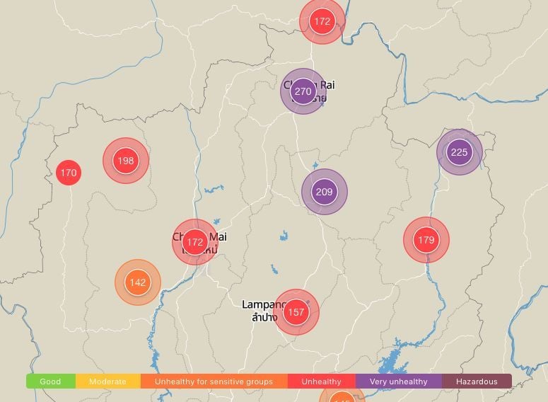
The air quality didn’t improve this morning, with IQAir recording “very unhealthy” air quality and hazardous PM2.5 dust levels at around 200 in parts of Chiang Mai and up to 270 around Chiang Rai today (below).
Thailand’s official safe level is 50: the World Health Organisation sets it at 25. Though it’s improved somewhat during the day, Chiang Mai once again rated world’s worst for air quality.
According a 2019 report, PM2.5 caused 23,800 premature deaths in Thailand in 2017.
Government spokeswoman Narumon Pinyosinwat says fires have definitely affected air quality, with 17 provinces in the North reporting an increase in levels of PM2.5 pollutants yesterday. Only two, Nakhon Sawan and Uthai Thani in the north-east reported PM2.5 readings below the Pollution Control Department’s “safe” threshold.
Chiang Dao district in Chiang Mai reported the highest PM2.5 reading in the North yesterday at 360.
Narumon says the worsening pollution is due to a combination of factors which include arson, drought and wind patterns which trap pollutants right over Thailand. Others say agribusiness, with its annual plantation field burnings, continues to exacerbate the problem.
According to satellite data, on Saturday there were 3,809 hotspots in Thailand, 5,061 in Laos and 10,061 in Myanmar. As of yesterday, 398 hotspots, nearly 10% of the country’s total, were found in Chiang Mai.
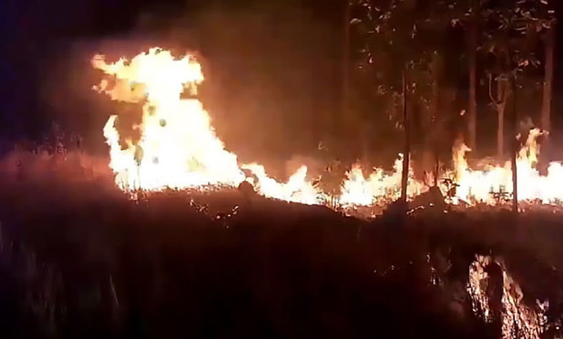
Most of the blazes were related to a continuing bushfire in Doi Suthep-Pui National Park, which suddenly raged out of control late on Saturday after burning for about a week.
SOURCE: Bangkok Post
Keep in contact with The Thaiger by following our Facebook page.
Never miss out on future posts by following The Thaiger.
Air Pollution
59 areas see excessive PM 2.5 dust in Bangkok today

59 areas in Bangkok are seeing excessive PM 2.5 dust ratings today as air quality is being described as moderate to poor. Din Daeng Road is being identified as the most polluted, according to the air4thai website of the Pollution Control Department. The amount of PM 2.5 dust is being measured at between 39 and 113 microns.
Din Daeng is also joining Bang Na-Trat highway in Bang Na district, Lat Phrao district and Sukhapibaan 5 Road in Sai Mai district in featuring PM10 dust in the atmosphere that is measuring between 54 and 155 microns.
Read more about Bangkok’s pollution today, and its causes, HERE.
The 59 areas that are considered polluted today are:
Hirunrujee sub-district, Thon Buri district
Kanchanapisek Road in Bang Khun Thian district
Bang Na sub-district
Song Khanong sub-district in Phra Pradaeng district
Din Daeng sub-district, Din Daeng district
Talat Kwan sub-district in Muang district of Nonthaburi
Omnoi sub-district in Krathumban district of Samut Sakhon
Paknam sub-district in Muang district of Samut Prakan
Bang Sao Thong sub-district
Khlong 1 sub-district in Khlong Luang district of Pathum Thani
Rama 4 Road in Pathumwan district
Intharapitak Road in Thon Buri district
Lat Phrao Road in Wang Thong Lang district
Din Daeng Road in Din Daeng district
Khlong Goom sub-district
Khlong Sam Wa district
Chom Thong district
Charunsanitwong Road in Bang Phlad district
Rama 2 Road in Bang Khun Thian district
Vibhavadi Rangsit highway in Din Daeng district
Sukhumvit Road in Phra Khanong district
Ratburana Road in Ratburana district
Rama 5 Road in Dusit district
Trimitr Road at Wongwian Odeon, Samphanthawong district
Rama 6 Road in Phya Thai district
Lat Phrao Road at Soi Lat Phrao 95 in Wang Thong Lang district
Rama 4 Road in front of Sam Yan Mitrtown, Pathumwan district
Narathiwat Road in Bang Rak district
Thung Wat Don sub-district
Rama 3-Charoen Krung Road in Bang Khor Laem district
Sukhumvit Road Soi 63 in Wattana district
Pattanakarn Road in Suan Luang district
Bang Na-Trat highway in Bang Na district
Pahonyothin Road at Kasetsart intersection, Chatuchak district
Don Mueang district
Sukhapibaan 5 Road in Sai Mai district
Nawamin Road in Bang Kapi district
Suan Sayam-Raminthra intersection in Kanna Yao district
Lat Krabang Road in Lat Krabang district
Seehaburanakit Road in Min Buri district
Liab Waree Road in Nong Chok district
Srinakharin Road in Prawet district
Ratchadapisek-Tha Phra Road in Thon Buri district
Charoen Nakhon Road in Khlong San district
Tha Phra intersection, Bangkok Yai district
Soi Nikhom Rodfai Thon Buri in Bangkok Noi district
Buddha Monthon 1 Road in Taling Chan district
Thawee Wattana Road in Thawee Wattana district
Aekkachai Road in Bang Bon district
Pracha-uthit Road in Thung Khru district
Samsen Road in Phra Nakhon district
Huay Khwang district
Khlong Toey sub-district
Ban Sue sub-district
Lat Phrao district
Thung Song Hong sub-district
Pahonyothin Road in Bang Khen district
Saphan Soong district
SOURCE: Thai PBS World
Keep in contact with The Thaiger by following our Facebook page.
Never miss out on future posts by following The Thaiger.
Environment
Thailand on fire – NASA satellite website tracks the country’s farm fires

Thailand is burning. The burning off of harvested crop plantations is lighting up the agricultural areas. The truth is starkly revealed in the live NASA satellite feeds which track the fires around the world.
CHART: Fires in the past 10 days around parts of Thailand – Firms.Modaps
Concentrations of the current fires can be seen in Central Thailand, north of Bangkok, parts of Isaan, north east of Bangkok, and around Chiang Mai in Northern Thailand. Notably the concentration of fires in northern Cambodia and across the north-western border in Myanmar, is also causing plenty of problems as the foreign smoke drifts across the borders. No matter what Thai officials do to enforce the rice, sugar and corn plantation burn-offs, there is little they can do about the haze drifting across the borders.
Bangkok, so close to clusters of fires, is in for a bad air pollution day anytime the light winds of the start of the year blow from the north or the east. The lack of rain adds to the problem, the annual problem, that engulfs Thailand’s capital during days between December and April, with the worst month, statistically, being March.
The alternative method of preparing for the next harvest, mechanical removal of the refuse and waste after harvesting, is both unpopular in Thailand and economically unviable for the small farmers whose margins remain thin with the multi-national buyers of their produce pushing for lower and lower prices every year.
In Chiang Mai, from January to the end of March, the locals even call it the ‘burning season’. Coupled with the hot season, the farmers in northern Thailand burn their fields to prepare land for the next harvest and also to get rid of biowastes like corn that can’t be sold in the market. It’s officially illegal to do the burn offs but the lack of enforcement leaves the problem unresolved and the smog and haze remain as predictable as the annual wet season.
Chiang Mai also has a local geographic problem which exacerbates the bad smoke pollution. The city is in a valley, surrounded by hills, trapping in the smoke and helping block any breezes that could otherwise blow it away.
For today, Bangkok’s air pollution is better than the past two days but still registering as ‘unhealthy for sensitive groups’ with city readings mostly between 140 – 170. Parts of the city, mostly south-east and south west, were registering readings above 300 in the past few days.
SOURCE: IQair.com
Watch this video for some more information about Bangkok’s smog…
Keep in contact with The Thaiger by following our Facebook page.
Never miss out on future posts by following The Thaiger.
Air Pollution
Bangkok’s air quality is ‘unhealthy’ today | VIDEO

Air quality around Bangkok this morning is awful. Partly due to the lack of wind to blow the smog out of the area. To the south of Bangkok, Samut Prakan and Samut Sakhon, the air quality is even worse with visibility on the ground cut to less than a kilometre. You would be well advised to reduce you activities outside on a day of high air pollution in the capital. The rating by airvisual.com is ‘unhealthy’.
Readings around the inner city vary between 190 – 220. Areas to the east, including around Suvarnabhumi Airport, are higher.
A lot of the smog and smoke is flowing down from the north and north east where plantation fires rage, mostly unenforced, this time of the year, from December to May. Farmers have been told, repeatedly, to avoid buying off the waste after harvests of corn, rice and sugar cane but officials have been disinclined to enforce the laws. Many of the farmers have long-term contracts with some of Thailand’s leading agri-business conglomerates.
Bangkok and the central region can expect many more months, especially as the temperatures rise throughout February, March and April and the winds remain low as the north-easterly monsoon weakens.
PHOTO: View across the Bangkok skyline from Sathorn this morning.
Keep in contact with The Thaiger by following our Facebook page.
Never miss out on future posts by following The Thaiger.
- Coronavirus (Covid-19)3 days ago
Thailand’s rich not eligible for 3,500 baht government handout
- Thailand3 days ago
Thailand to introduce 300 baht “tourism fee” to insure foreign visitors, manage tourist destinations
- Business4 days ago
Future of Thai department stores is being redefined
- Crime4 days ago
Thai brothers charged with trafficking Thai women to Brunei for prostitution
- Bangkok3 days ago
Bangkok condo prices expected to continue to fall this year
- Pattaya4 days ago
Pattaya massage shop raided for allegedly violating closure order
- Coronavirus (Covid-19)3 days ago
CCSA Update: 271 new Covid-19 cases and 2 deaths
- Air Pollution3 days ago
Air pollution at “unhealthy levels” in 64 areas in Bangkok