Airborne Virus spreads science across the globe
While many visitors arrived at Phuket International Airport in the run-up to last month’s Songkran Festival, a French couple, whose microlight aircraft landed there on April 11 for safety reasons, raised more than a few eyebrows at the busy facility. Stephen Fein reports:
PHUKET: The couple, 31-year-old Adrien Normier and his fiancée Clementine Bacri, 28, are on an around-the-world journey of scientific exploration quite unlike any other that has come before it. They were en route from Penang, Malaysia to U-Tapao airport, in Thailand’s Chonburi province, when cloudy conditions atop a hill range east of Phuket made it impossible for their tiny aircraft to continue onward.
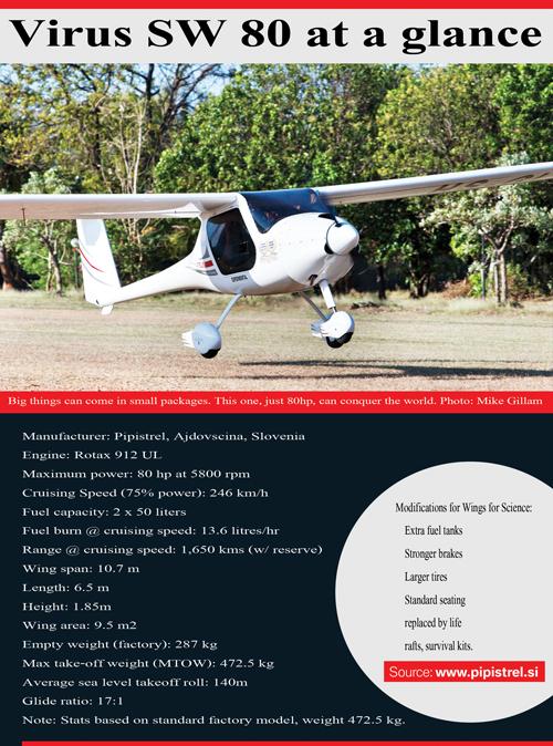
The plane, a 6.2 meter long Pipistrel Virus Short Wing [details below], can only be flown “line of sight”, which in aviator parlance means VFR (visual flight rules). With almost zero visibility, the pair had no option other than to divert to the nearest suitable airport they were aware of at the time.
During their short and completely unplanned stay on the island, the Parisian couple sat down with the Phuket Gazette to explain how their dream project, which they call ‘Wings For Science’, came to be.
“We began designing this project five years ago, when we decided to do something different and useful for at least a year. Some friends of mine in France had already asked me to do science using small aircraft,” said Adrien. Shortly thereafter, the young AirFrance pilot had a burst of inspiration.
“We’re going to do this in different places all around the world! It’s going to be interesting’,” he recounted.
Their goal established, Clem and Adrien then sent an offer via France’s National Center for Scientific Research (CNRS) to get the message out that the couple would be more than happy to use a light sports aircraft to conduct free research in remote locations around the globe. In return, all they asked for was the right to interview the researchers and discover what they were doing, then shooting short films about the work.
“We wanted to be useful and to discover the world in a way different from what we were used to. We thought that taking part in interesting projects would be a great way to discover new places and the people who live there,” explained Clem, a lawyer by trade who practices in both France and Luxembourg.
After lining up an impressive array of collaborators and sponsors, the couple’s first project involved researching atmospheric pollutants in the city of Luxembourg in December 2012. Taking aerial photographs, they helped create three dimensional images of the inner city using specially-developed software that is the key to much of their work.
From there, taking turns flying a maximum of five and a half hours a day, they headed north to take part in creating three-dimensional models of two islands off Iceland.
Then they headed even further north to take part in two projects in Greenland.
The three dimensional models their software helps create allow researchers to gain valuable, possibly lifesaving, geophysical data about the landforms they study. For example, the images they produce of a volcano dome enables researchers to predict points of collapse during an eruption, and the likelihood, or otherwise, that lava flows will run into inhabited areas nearby.
The Virus, with its low stall speed and hi-tech photographic equipment, is an ideal platform from which to create detailed 3D images that would be impossible from either a land-based perspective or by satellite imagery, explained Adrien.
“This gets you a very high-resolution 3D model, with a clarity of the ground that is not possible with Google Earth,” he says.
“Also, in Google Earth you have pictures without any notion of the volume [of landforms],” notes Clem.
Not all of their work has involved mountainous landforms, however. They also marked the movement of mudflats in mangrove forests in French Guyana, taking tens of thousands of images and “creating a sort of private Google Earth database for the research institute conducting the study there,” Adrien said.
Apart from 3D mapping, the pair have also done some “observation flights” in search of specific features, such as spotting whales for an oceanographic campaign in Canada that collects biodata on individual migrating cetaceans.
“With the airplane we can extend the range of prospection of the whales,” said Adrien.
The intrepid couple have also successfully taken part in several “aerial archeology” research projects.
Asked how microlight aircraft could be involved in a pursuit more often associated with excavation pits, dirt and pickaxes, Adrien explained.
“In some very specific environments, you can actually look for archeological remains from the air. In Europe, we looked for and found Roman archeological artifacts, such as villas, using this method,” he said.
He went on to note that in the dry European summer, crops can be very sensitive to amounts of water that get collected or trapped by stone formations beneath the earth’s surface. Common crops, such as oats and wheat that tend to grow at the same rate under uniform conditions, can tap into these precious water sources.
The plants that do it tend to grow taller than those that do not, and the differences can form a sort of contour indicating the position of subsurface structures, including those left behind by ancient civilizations. Such patterns may be discernable from the air, but go unnoticed by people on the ground – including those who planted the crops.
“When it’s desert, you can really see stuff. You can see hilltops shaped like squares and you can see that there was a pyramid there. In Peru it is very obvious. There are thousands and thousands of remains,” Adrien said.
During their work in Peru, home to the world famous Nazca Lines geoglyphs, they detected a previously unknown formation of stones that are now thought to be the remains of an ancient cemetery that could be up to 5,000 years old, according to initial estimates.
A photo of a shaman performing a religious rite at the site is among the many interesting images available on their Facebook page, and on the many other social media the technically savvy pair use to keep the public up to date on their journey of discovery.
The only break in the couple’s circumnavigation of the planet came when they had to ship the aircraft in a container from South America all the way to Australia.
SAFETY CONCERNS
As is now becoming standard on many small aircraft, the Virus comes equipped with a “rocket-propelled parachute ballistic recovery system”, which means that if worse comes to worst they can simply pull a lever and a parachute will deploy, allowing the entire plane to come safely to the ground. Fortunately, the pair had yet to deploy this technology at the time they left Phuket.
Safety is always of paramount importance to the researchers, however.
“It is actually dangerous, but we take every precaution possible because we want to come back to do other adventures,” said Clem. “We wait when the weather is not good or we divert, as we have done here. We also have a Luxembourg-based meteorologist who communicates with us through satellite phone to update all of the meteorological aspects of the flight,” said Clem.
Asked how a single weatherman could remain on call 24 hours a day, the couple laughed.
Their eye in the sky, as it were, is a “very cool and nice” retired meteorologist named Ernest who “has trouble sleeping and is always there on the line when we need him. We couldn’t do it without him,” Clementine said.
Asked what their worst experiences have been, Adrien was quick to say they had all been on the “administrative side”.
As just one example, after they chose to divert
— Stephen Fein
Latest Thailand News


Follow The Thaiger on Google News: