Amber heat-health alert as UK temperatures set to surpass 30C this weekend
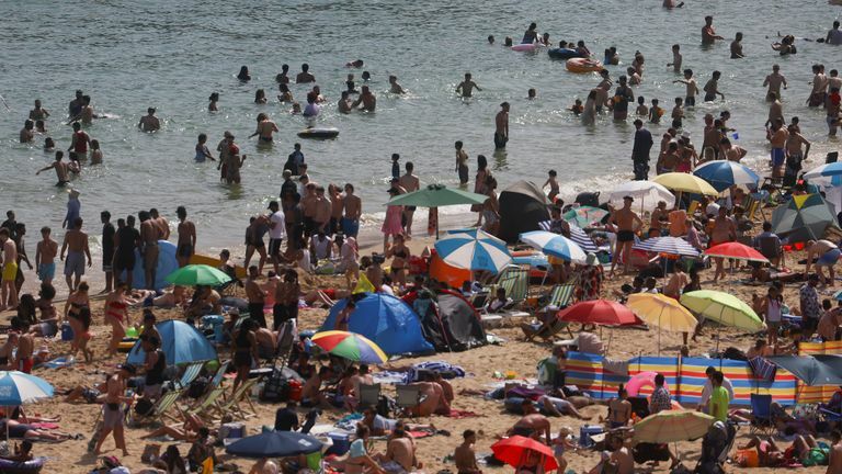
An amber heat-health warning has been issued as the UK braces for a surge in temperatures, potentially exceeding 30C in some regions. The UK Health Security Agency (UKHSA) has raised its alert level after the Met Office forecasted that temperatures could reach up to 31C (88F) on Saturday. Aiden McGivern, a forecaster, mentioned that the highest temperatures are expected between London, Cambridgeshire, the Midlands, and North West England, making it the hottest day of the year so far.
The amber alert, which signifies that the weather could impact the wider population and not just vulnerable individuals, will cover the West Midlands, East Midlands, East of England, South East, and South West. These regions are predicted to be hotter than popular tourist destinations such as Ibiza, Tenerife, and Marbella in Spain. The UKHSA explained that the decision to issue an amber alert was based on the latest Met Office forecasts, which indicate a high likelihood of rapidly increasing temperatures over the weekend, as well as high overnight temperatures.
Yellow alerts have also been issued for the North East, North West, and Yorkshire and Humber, while London’s alert level remains the same. The alerts will be in effect from 9am on Friday until 9am on Monday, June 12. However, coastal areas in the East of England and North East are expected to be much cooler, with temperatures of 17C in Newcastle and 19C in Middlesborough. Eastern Scotland’s Aberdeenshire coast will experience a “chilly north sea breeze” with temperatures dropping to 13C, while the southwest of the country is predicted to reach 28C.
The rise in temperatures and increased humidity could trigger “lively downpours,” particularly in parts of southern England, the Midlands, and Wales. The Met Office has also issued a yellow alert for thunderstorms covering Wales, southern, and western England from 2pm until 9pm on Saturday. Light winds will cause showers and thunderstorms to be slow-moving, making them “hit and miss,” but with the potential for a “serious impact.” Affected areas could experience more than 30-40mm of rain in a few hours, accompanied by “hail, gusty winds and frequent lightning,” according to McGivern.
Met Office meteorologist Craig Snell said, “I’d say 95% of people will probably be dry, 5% will be very wet. So you balance that out and the vast majority of the UK is still dry.” The heatwave comes as new data reveals that England has experienced almost no rain in the past three weeks. Less than 1mm of rain has fallen in the South East and North East since May 31, with the rest of England remaining dry.
River levels have dropped at all sites monitored by the Environment Agency, and rainfall in May was 43% of the long-term average for north-west England and 86% in the east. However, most rivers across the south are reported to have normal levels. The Met Office stated that it is “not rare” to have a prolonged dry spell at this time of year but warned that it could increase the risk of surface water flooding and potential travel disruption over the weekend.


Latest Thailand News


Follow The Thaiger on Google News: